You are here: Home > Network List > TA - USArray Transportable Network (new EarthScope stations) Stations List
> Station U34A Anderson Ranch, Garber, OK, USA > Earthquake Result Viewer
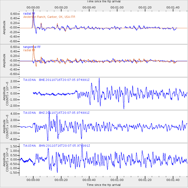
U34A Anderson Ranch, Garber, OK, USA - Earthquake Result Viewer
| Earthquake location: |
Alaska Peninsula |
| Earthquake latitude/longitude: |
54.8/-161.3 |
| Earthquake time(UTC): |
2011/07/16 (197) 19:59:12 GMT |
| Earthquake Depth: |
36 km |
| Earthquake Magnitude: |
6.3 MB, 5.9 MS, 6.2 MW, 6.1 MW |
| Earthquake Catalog/Contributor: |
WHDF/NEIC |
|
| Network: |
TA USArray Transportable Network (new EarthScope stations) |
| Station: |
U34A Anderson Ranch, Garber, OK, USA |
| Lat/Lon: |
36.44 N/97.54 W |
| Elevation: |
345 m |
|
| Distance: |
46.5 deg |
| Az: |
85.903 deg |
| Baz: |
314.241 deg |
| Ray Param: |
0.07054563 |
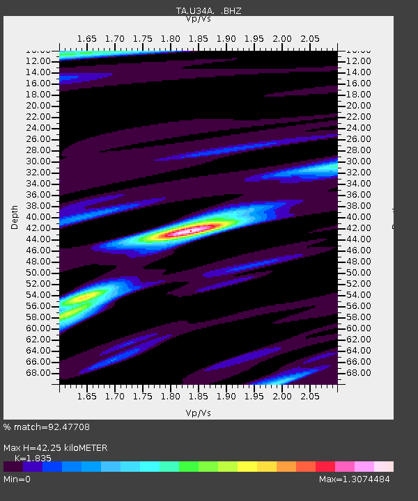
| Estimated Moho Depth: |
42.25 km |
| Estimated Crust Vp/Vs: |
1.84 |
| Assumed Crust Vp: |
6.483 km/s |
| Estimated Crust Vs: |
3.533 km/s |
| Estimated Crust Poisson's Ratio: |
0.29 |
|
| Radial Match: |
92.47708 % |
| Radial Bump: |
368 |
| Transverse Match: |
80.153854 % |
| Transverse Bump: |
400 |
| SOD ConfigId: |
401841 |
| Insert Time: |
2011-12-21 03:35:50.717 +0000 |
| GWidth: |
2.5 |
| Max Bumps: |
400 |
| Tol: |
0.001 |
|
Signal To Noise
| Channel | StoN | STA | LTA |
| TA:U34A: :BHZ:20110716T20:07:05.974991Z | 11.9288645 | 8.7625386E-7 | 7.34566E-8 |
| TA:U34A: :BHN:20110716T20:07:05.974991Z | 2.8151386 | 3.9444694E-7 | 1.4011636E-7 |
| TA:U34A: :BHE:20110716T20:07:05.974991Z | 3.189344 | 3.510375E-7 | 1.10065734E-7 |
| Arrivals |
| Ps | 5.8 SECOND |
| PpPs | 17 SECOND |
| PsPs/PpSs | 23 SECOND |


