You are here: Home > Network List > TA - USArray Transportable Network (new EarthScope stations) Stations List
> Station U33A Lingo Farm, Meno, OK, USA > Earthquake Result Viewer
U33A Lingo Farm, Meno, OK, USA - Earthquake Result Viewer
| Earthquake location: |
Alaska Peninsula |
| Earthquake latitude/longitude: |
54.8/-161.3 |
| Earthquake time(UTC): |
2011/07/16 (197) 19:59:12 GMT |
| Earthquake Depth: |
36 km |
| Earthquake Magnitude: |
6.3 MB, 5.9 MS, 6.2 MW, 6.1 MW |
| Earthquake Catalog/Contributor: |
WHDF/NEIC |
|
| Network: |
TA USArray Transportable Network (new EarthScope stations) |
| Station: |
U33A Lingo Farm, Meno, OK, USA |
| Lat/Lon: |
36.43 N/98.11 W |
| Elevation: |
393 m |
|
| Distance: |
46.1 deg |
| Az: |
86.356 deg |
| Baz: |
314.213 deg |
| Ray Param: |
0.07075075 |
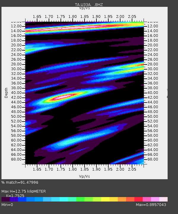
| Estimated Moho Depth: |
12.75 km |
| Estimated Crust Vp/Vs: |
1.75 |
| Assumed Crust Vp: |
6.426 km/s |
| Estimated Crust Vs: |
3.667 km/s |
| Estimated Crust Poisson's Ratio: |
0.26 |
|
| Radial Match: |
91.47996 % |
| Radial Bump: |
362 |
| Transverse Match: |
73.17972 % |
| Transverse Bump: |
400 |
| SOD ConfigId: |
401841 |
| Insert Time: |
2011-12-21 03:36:20.918 +0000 |
| GWidth: |
2.5 |
| Max Bumps: |
400 |
| Tol: |
0.001 |
|
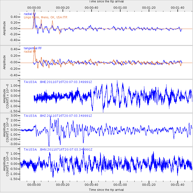
Signal To Noise
| Channel | StoN | STA | LTA |
| TA:U33A: :BHZ:20110716T20:07:03.349991Z | 8.221659 | 6.733836E-7 | 8.190362E-8 |
| TA:U33A: :BHN:20110716T20:07:03.349991Z | 1.3725387 | 3.4536146E-7 | 2.5162237E-7 |
| TA:U33A: :BHE:20110716T20:07:03.349991Z | 1.7311213 | 3.6131505E-7 | 2.0871737E-7 |
| Arrivals |
| Ps | 1.6 SECOND |
| PpPs | 5.1 SECOND |
| PsPs/PpSs | 6.7 SECOND |


