You are here: Home > Network List > TA - USArray Transportable Network (new EarthScope stations) Stations List
> Station V33A Lossen Ranch, Watonga, OK, USA > Earthquake Result Viewer
V33A Lossen Ranch, Watonga, OK, USA - Earthquake Result Viewer
*The percent match for this event was below the threshold and hence no stack was calculated.
| Earthquake location: |
Alaska Peninsula |
| Earthquake latitude/longitude: |
54.8/-161.3 |
| Earthquake time(UTC): |
2011/07/16 (197) 19:59:12 GMT |
| Earthquake Depth: |
36 km |
| Earthquake Magnitude: |
6.3 MB, 5.9 MS, 6.2 MW, 6.1 MW |
| Earthquake Catalog/Contributor: |
WHDF/NEIC |
|
| Network: |
TA USArray Transportable Network (new EarthScope stations) |
| Station: |
V33A Lossen Ranch, Watonga, OK, USA |
| Lat/Lon: |
35.82 N/98.29 W |
| Elevation: |
420 m |
|
| Distance: |
46.5 deg |
| Az: |
87.095 deg |
| Baz: |
314.621 deg |
| Ray Param: |
$rayparam |
*The percent match for this event was below the threshold and hence was not used in the summary stack. |
|
| Radial Match: |
79.95944 % |
| Radial Bump: |
400 |
| Transverse Match: |
56.379456 % |
| Transverse Bump: |
400 |
| SOD ConfigId: |
401841 |
| Insert Time: |
2011-12-21 03:37:14.188 +0000 |
| GWidth: |
2.5 |
| Max Bumps: |
400 |
| Tol: |
0.001 |
|
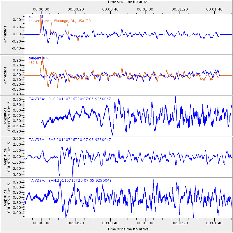
Signal To Noise
| Channel | StoN | STA | LTA |
| TA:V33A: :BHZ:20110716T20:07:05.925004Z | 4.0543165 | 6.1185693E-7 | 1.5091494E-7 |
| TA:V33A: :BHN:20110716T20:07:05.925004Z | 0.954266 | 1.9746714E-7 | 2.0693092E-7 |
| TA:V33A: :BHE:20110716T20:07:05.925004Z | 1.1760026 | 2.781001E-7 | 2.3647914E-7 |
| Arrivals |
| Ps | |
| PpPs | |
| PsPs/PpSs | |


