You are here: Home > Network List > TA - USArray Transportable Network (new EarthScope stations) Stations List
> Station V34A Guthrie, OK, USA > Earthquake Result Viewer
V34A Guthrie, OK, USA - Earthquake Result Viewer
| Earthquake location: |
Alaska Peninsula |
| Earthquake latitude/longitude: |
54.8/-161.3 |
| Earthquake time(UTC): |
2011/07/16 (197) 19:59:12 GMT |
| Earthquake Depth: |
36 km |
| Earthquake Magnitude: |
6.3 MB, 5.9 MS, 6.2 MW, 6.1 MW |
| Earthquake Catalog/Contributor: |
WHDF/NEIC |
|
| Network: |
TA USArray Transportable Network (new EarthScope stations) |
| Station: |
V34A Guthrie, OK, USA |
| Lat/Lon: |
35.83 N/97.52 W |
| Elevation: |
329 m |
|
| Distance: |
46.9 deg |
| Az: |
86.478 deg |
| Baz: |
314.646 deg |
| Ray Param: |
0.0702633 |
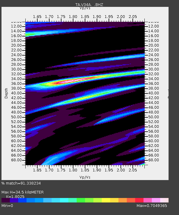
| Estimated Moho Depth: |
34.5 km |
| Estimated Crust Vp/Vs: |
1.80 |
| Assumed Crust Vp: |
6.426 km/s |
| Estimated Crust Vs: |
3.565 km/s |
| Estimated Crust Poisson's Ratio: |
0.28 |
|
| Radial Match: |
91.338234 % |
| Radial Bump: |
400 |
| Transverse Match: |
70.75873 % |
| Transverse Bump: |
400 |
| SOD ConfigId: |
401841 |
| Insert Time: |
2011-12-21 03:37:22.180 +0000 |
| GWidth: |
2.5 |
| Max Bumps: |
400 |
| Tol: |
0.001 |
|
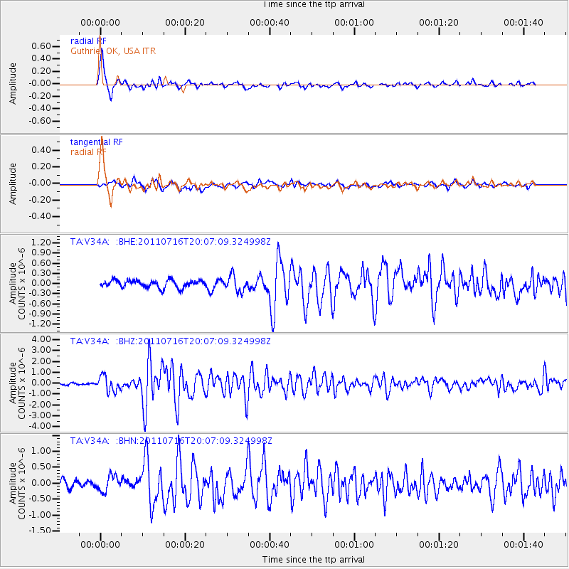
Signal To Noise
| Channel | StoN | STA | LTA |
| TA:V34A: :BHZ:20110716T20:07:09.324998Z | 8.024521 | 7.085366E-7 | 8.829643E-8 |
| TA:V34A: :BHN:20110716T20:07:09.324998Z | 2.0308726 | 2.546899E-7 | 1.254091E-7 |
| TA:V34A: :BHE:20110716T20:07:09.324998Z | 2.141351 | 2.3269314E-7 | 1.0866651E-7 |
| Arrivals |
| Ps | 4.6 SECOND |
| PpPs | 14 SECOND |
| PsPs/PpSs | 19 SECOND |


