You are here: Home > Network List > TA - USArray Transportable Network (new EarthScope stations) Stations List
> Station Z33A Whitaker Ranch, Olney, TX, USA > Earthquake Result Viewer
Z33A Whitaker Ranch, Olney, TX, USA - Earthquake Result Viewer
| Earthquake location: |
Alaska Peninsula |
| Earthquake latitude/longitude: |
54.8/-161.3 |
| Earthquake time(UTC): |
2011/07/16 (197) 19:59:12 GMT |
| Earthquake Depth: |
36 km |
| Earthquake Magnitude: |
6.3 MB, 5.9 MS, 6.2 MW, 6.1 MW |
| Earthquake Catalog/Contributor: |
WHDF/NEIC |
|
| Network: |
TA USArray Transportable Network (new EarthScope stations) |
| Station: |
Z33A Whitaker Ranch, Olney, TX, USA |
| Lat/Lon: |
33.29 N/98.76 W |
| Elevation: |
362 m |
|
| Distance: |
48.0 deg |
| Az: |
89.895 deg |
| Baz: |
316.252 deg |
| Ray Param: |
0.06956422 |
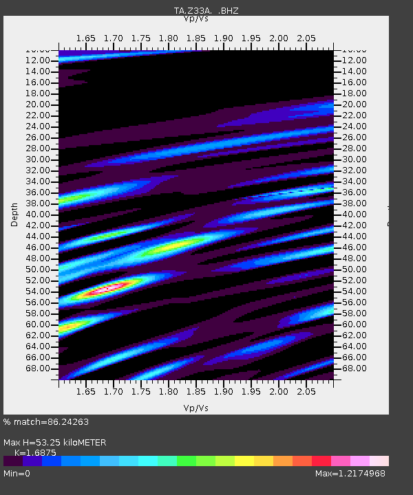
| Estimated Moho Depth: |
53.25 km |
| Estimated Crust Vp/Vs: |
1.69 |
| Assumed Crust Vp: |
6.426 km/s |
| Estimated Crust Vs: |
3.808 km/s |
| Estimated Crust Poisson's Ratio: |
0.23 |
|
| Radial Match: |
86.24263 % |
| Radial Bump: |
400 |
| Transverse Match: |
82.31958 % |
| Transverse Bump: |
400 |
| SOD ConfigId: |
401841 |
| Insert Time: |
2011-12-21 03:37:30.274 +0000 |
| GWidth: |
2.5 |
| Max Bumps: |
400 |
| Tol: |
0.001 |
|
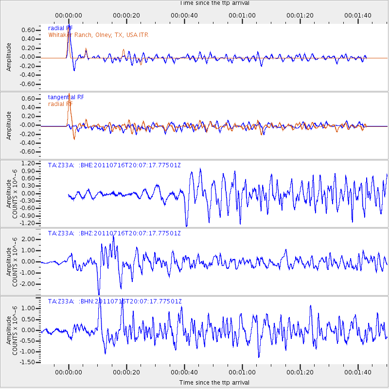
Signal To Noise
| Channel | StoN | STA | LTA |
| TA:Z33A: :BHZ:20110716T20:07:17.77501Z | 6.9956503 | 4.841645E-7 | 6.9209364E-8 |
| TA:Z33A: :BHN:20110716T20:07:17.77501Z | 2.6876829 | 2.1562852E-7 | 8.02284E-8 |
| TA:Z33A: :BHE:20110716T20:07:17.77501Z | 2.9521956 | 2.483534E-7 | 8.412497E-8 |
| Arrivals |
| Ps | 6.1 SECOND |
| PpPs | 21 SECOND |
| PsPs/PpSs | 27 SECOND |


