You are here: Home > Network List > TA - USArray Transportable Network (new EarthScope stations) Stations List
> Station Y33A Hilltop Ranch, Iowa Park, TX, USA > Earthquake Result Viewer
Y33A Hilltop Ranch, Iowa Park, TX, USA - Earthquake Result Viewer
| Earthquake location: |
Alaska Peninsula |
| Earthquake latitude/longitude: |
54.8/-161.3 |
| Earthquake time(UTC): |
2011/07/16 (197) 19:59:12 GMT |
| Earthquake Depth: |
36 km |
| Earthquake Magnitude: |
6.3 MB, 5.9 MS, 6.2 MW, 6.1 MW |
| Earthquake Catalog/Contributor: |
WHDF/NEIC |
|
| Network: |
TA USArray Transportable Network (new EarthScope stations) |
| Station: |
Y33A Hilltop Ranch, Iowa Park, TX, USA |
| Lat/Lon: |
34.01 N/98.63 W |
| Elevation: |
321 m |
|
| Distance: |
47.6 deg |
| Az: |
89.107 deg |
| Baz: |
315.8 deg |
| Ray Param: |
0.069835916 |
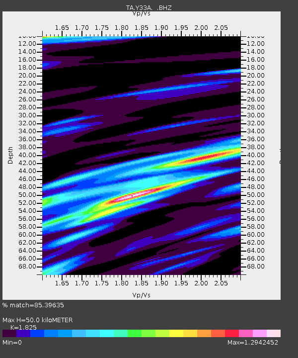
| Estimated Moho Depth: |
50.0 km |
| Estimated Crust Vp/Vs: |
1.83 |
| Assumed Crust Vp: |
6.315 km/s |
| Estimated Crust Vs: |
3.46 km/s |
| Estimated Crust Poisson's Ratio: |
0.29 |
|
| Radial Match: |
85.39635 % |
| Radial Bump: |
400 |
| Transverse Match: |
73.7513 % |
| Transverse Bump: |
400 |
| SOD ConfigId: |
401841 |
| Insert Time: |
2011-12-21 03:38:01.642 +0000 |
| GWidth: |
2.5 |
| Max Bumps: |
400 |
| Tol: |
0.001 |
|

Signal To Noise
| Channel | StoN | STA | LTA |
| TA:Y33A: :BHZ:20110716T20:07:14.40001Z | 7.4610434 | 5.148462E-7 | 6.9004585E-8 |
| TA:Y33A: :BHN:20110716T20:07:14.40001Z | 2.7638755 | 2.6876643E-7 | 9.72426E-8 |
| TA:Y33A: :BHE:20110716T20:07:14.40001Z | 3.4607964 | 2.7085483E-7 | 7.826373E-8 |
| Arrivals |
| Ps | 6.9 SECOND |
| PpPs | 21 SECOND |
| PsPs/PpSs | 28 SECOND |


