You are here: Home > Network List > TA - USArray Transportable Network (new EarthScope stations) Stations List
> Station 335A Moody, TX, USA > Earthquake Result Viewer
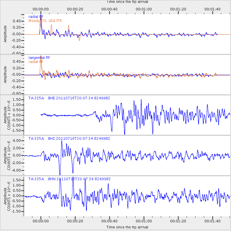
335A Moody, TX, USA - Earthquake Result Viewer

| Earthquake location: |
Alaska Peninsula |
| Earthquake latitude/longitude: |
54.8/-161.3 |
| Earthquake time(UTC): |
2011/07/16 (197) 19:59:12 GMT |
| Earthquake Depth: |
36 km |
| Earthquake Magnitude: |
6.3 MB, 5.9 MS, 6.2 MW, 6.1 MW |
| Earthquake Catalog/Contributor: |
WHDF/NEIC |
|
| Network: |
TA USArray Transportable Network (new EarthScope stations) |
| Station: |
335A Moody, TX, USA |
| Lat/Lon: |
31.28 N/97.43 W |
| Elevation: |
217 m |
|
| Distance: |
50.2 deg |
| Az: |
90.61 deg |
| Baz: |
317.432 deg |
| Ray Param: |
0.068119526 |
| Estimated Moho Depth: |
41.25 km |
| Estimated Crust Vp/Vs: |
1.72 |
| Assumed Crust Vp: |
6.347 km/s |
| Estimated Crust Vs: |
3.685 km/s |
| Estimated Crust Poisson's Ratio: |
0.25 |
|
| Radial Match: |
95.544685 % |
| Radial Bump: |
400 |
| Transverse Match: |
81.56815 % |
| Transverse Bump: |
400 |
| SOD ConfigId: |
401841 |
| Insert Time: |
2011-12-21 03:39:10.798 +0000 |
| GWidth: |
2.5 |
| Max Bumps: |
400 |
| Tol: |
0.001 |
|
Signal To Noise
| Channel | StoN | STA | LTA |
| TA:335A: :BHZ:20110716T20:07:34.824998Z | 14.643122 | 7.5450424E-7 | 5.1526186E-8 |
| TA:335A: :BHN:20110716T20:07:34.824998Z | 6.1944923 | 2.6509665E-7 | 4.279554E-8 |
| TA:335A: :BHE:20110716T20:07:34.824998Z | 5.3113427 | 2.6635468E-7 | 5.0148277E-8 |
| Arrivals |
| Ps | 5.0 SECOND |
| PpPs | 17 SECOND |
| PsPs/PpSs | 22 SECOND |


