You are here: Home > Network List > TA - USArray Transportable Network (new EarthScope stations) Stations List
> Station 733A Divot King Ranch, Dilley, TX, USA > Earthquake Result Viewer
733A Divot King Ranch, Dilley, TX, USA - Earthquake Result Viewer
| Earthquake location: |
Alaska Peninsula |
| Earthquake latitude/longitude: |
54.8/-161.3 |
| Earthquake time(UTC): |
2011/07/16 (197) 19:59:12 GMT |
| Earthquake Depth: |
36 km |
| Earthquake Magnitude: |
6.3 MB, 5.9 MS, 6.2 MW, 6.1 MW |
| Earthquake Catalog/Contributor: |
WHDF/NEIC |
|
| Network: |
TA USArray Transportable Network (new EarthScope stations) |
| Station: |
733A Divot King Ranch, Dilley, TX, USA |
| Lat/Lon: |
28.72 N/99.29 W |
| Elevation: |
169 m |
|
| Distance: |
51.1 deg |
| Az: |
94.373 deg |
| Baz: |
318.89 deg |
| Ray Param: |
0.067583434 |
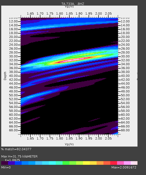
| Estimated Moho Depth: |
31.75 km |
| Estimated Crust Vp/Vs: |
1.86 |
| Assumed Crust Vp: |
6.347 km/s |
| Estimated Crust Vs: |
3.408 km/s |
| Estimated Crust Poisson's Ratio: |
0.30 |
|
| Radial Match: |
92.04377 % |
| Radial Bump: |
400 |
| Transverse Match: |
73.36906 % |
| Transverse Bump: |
400 |
| SOD ConfigId: |
401841 |
| Insert Time: |
2011-12-21 03:39:46.471 +0000 |
| GWidth: |
2.5 |
| Max Bumps: |
400 |
| Tol: |
0.001 |
|

Signal To Noise
| Channel | StoN | STA | LTA |
| TA:733A: :BHZ:20110716T20:07:41.02501Z | 6.822097 | 5.4894366E-7 | 8.046553E-8 |
| TA:733A: :BHN:20110716T20:07:41.02501Z | 1.9884634 | 2.645975E-7 | 1.3306631E-7 |
| TA:733A: :BHE:20110716T20:07:41.02501Z | 0.89405763 | 1.4996037E-7 | 1.677301E-7 |
| Arrivals |
| Ps | 4.5 SECOND |
| PpPs | 14 SECOND |
| PsPs/PpSs | 18 SECOND |


