You are here: Home > Network List > TA - USArray Transportable Network (new EarthScope stations) Stations List
> Station 633A Saathoff Ranch, Hondo, TX, USA > Earthquake Result Viewer
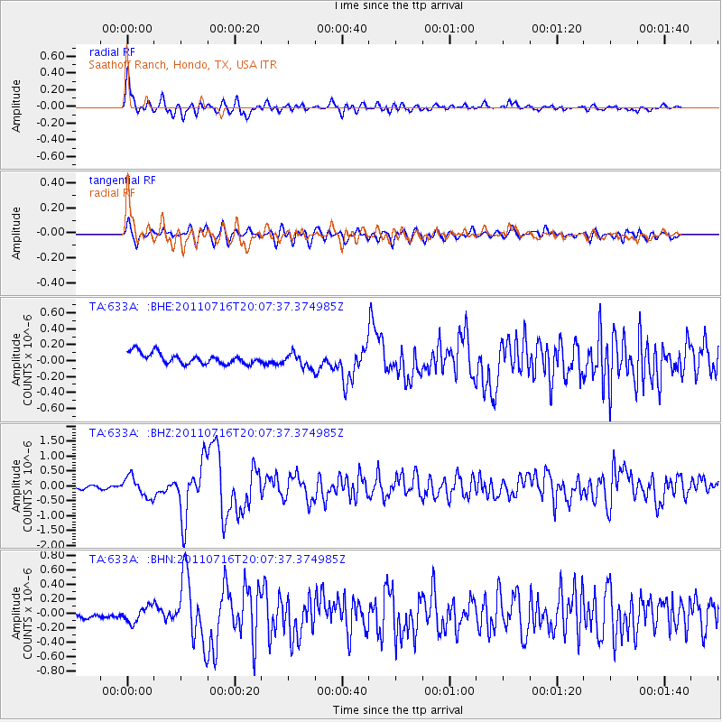
633A Saathoff Ranch, Hondo, TX, USA - Earthquake Result Viewer
| Earthquake location: |
Alaska Peninsula |
| Earthquake latitude/longitude: |
54.8/-161.3 |
| Earthquake time(UTC): |
2011/07/16 (197) 19:59:12 GMT |
| Earthquake Depth: |
36 km |
| Earthquake Magnitude: |
6.3 MB, 5.9 MS, 6.2 MW, 6.1 MW |
| Earthquake Catalog/Contributor: |
WHDF/NEIC |
|
| Network: |
TA USArray Transportable Network (new EarthScope stations) |
| Station: |
633A Saathoff Ranch, Hondo, TX, USA |
| Lat/Lon: |
29.46 N/99.18 W |
| Elevation: |
320 m |
|
| Distance: |
50.6 deg |
| Az: |
93.646 deg |
| Baz: |
318.487 deg |
| Ray Param: |
0.06789242 |
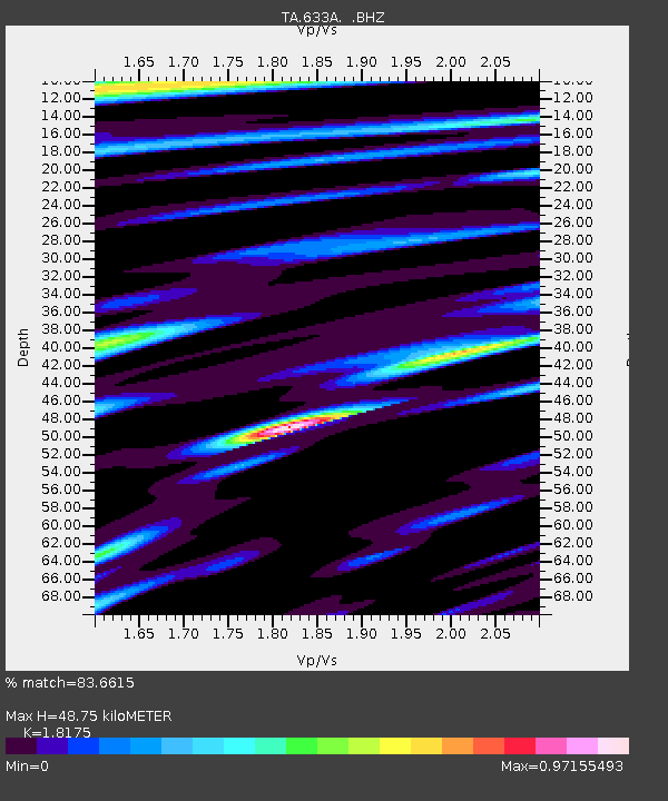
| Estimated Moho Depth: |
48.75 km |
| Estimated Crust Vp/Vs: |
1.82 |
| Assumed Crust Vp: |
6.347 km/s |
| Estimated Crust Vs: |
3.492 km/s |
| Estimated Crust Poisson's Ratio: |
0.28 |
|
| Radial Match: |
83.6615 % |
| Radial Bump: |
400 |
| Transverse Match: |
67.2532 % |
| Transverse Bump: |
400 |
| SOD ConfigId: |
401841 |
| Insert Time: |
2011-12-21 03:39:57.451 +0000 |
| GWidth: |
2.5 |
| Max Bumps: |
400 |
| Tol: |
0.001 |
|
Signal To Noise
| Channel | StoN | STA | LTA |
| TA:633A: :BHZ:20110716T20:07:37.374985Z | 5.629713 | 3.414061E-7 | 6.06436E-8 |
| TA:633A: :BHN:20110716T20:07:37.374985Z | 2.6530547 | 1.09655474E-7 | 4.133178E-8 |
| TA:633A: :BHE:20110716T20:07:37.374985Z | 1.3613652 | 9.2529326E-8 | 6.7968045E-8 |
| Arrivals |
| Ps | 6.6 SECOND |
| PpPs | 20 SECOND |
| PsPs/PpSs | 27 SECOND |


