You are here: Home > Network List > TA - USArray Transportable Network (new EarthScope stations) Stations List
> Station 337A Centerville, TX, USA > Earthquake Result Viewer
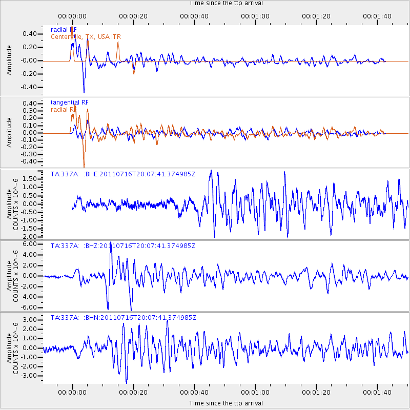
337A Centerville, TX, USA - Earthquake Result Viewer
| Earthquake location: |
Alaska Peninsula |
| Earthquake latitude/longitude: |
54.8/-161.3 |
| Earthquake time(UTC): |
2011/07/16 (197) 19:59:12 GMT |
| Earthquake Depth: |
36 km |
| Earthquake Magnitude: |
6.3 MB, 5.9 MS, 6.2 MW, 6.1 MW |
| Earthquake Catalog/Contributor: |
WHDF/NEIC |
|
| Network: |
TA USArray Transportable Network (new EarthScope stations) |
| Station: |
337A Centerville, TX, USA |
| Lat/Lon: |
31.32 N/95.89 W |
| Elevation: |
150 m |
|
| Distance: |
51.1 deg |
| Az: |
89.323 deg |
| Baz: |
317.413 deg |
| Ray Param: |
0.06755524 |
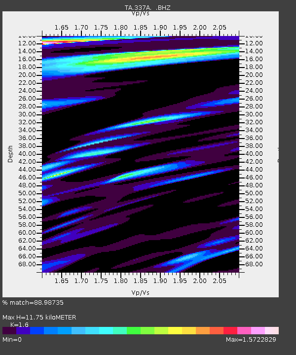
| Estimated Moho Depth: |
11.75 km |
| Estimated Crust Vp/Vs: |
1.60 |
| Assumed Crust Vp: |
5.738 km/s |
| Estimated Crust Vs: |
3.587 km/s |
| Estimated Crust Poisson's Ratio: |
0.18 |
|
| Radial Match: |
88.98735 % |
| Radial Bump: |
400 |
| Transverse Match: |
74.74351 % |
| Transverse Bump: |
400 |
| SOD ConfigId: |
401841 |
| Insert Time: |
2011-12-21 03:42:07.093 +0000 |
| GWidth: |
2.5 |
| Max Bumps: |
400 |
| Tol: |
0.001 |
|
Signal To Noise
| Channel | StoN | STA | LTA |
| TA:337A: :BHZ:20110716T20:07:41.374985Z | 6.9864087 | 9.2452524E-7 | 1.3233198E-7 |
| TA:337A: :BHN:20110716T20:07:41.374985Z | 2.5267308 | 5.065812E-7 | 2.004888E-7 |
| TA:337A: :BHE:20110716T20:07:41.374985Z | 1.1451827 | 2.0690956E-7 | 1.806782E-7 |
| Arrivals |
| Ps | 1.3 SECOND |
| PpPs | 5.1 SECOND |
| PsPs/PpSs | 6.4 SECOND |


