You are here: Home > Network List > TA - USArray Transportable Network (new EarthScope stations) Stations List
> Station 437A Phaontom Ranch, North Zulch, TX, USA > Earthquake Result Viewer
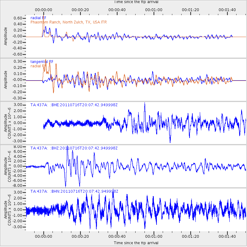
437A Phaontom Ranch, North Zulch, TX, USA - Earthquake Result Viewer
| Earthquake location: |
Alaska Peninsula |
| Earthquake latitude/longitude: |
54.8/-161.3 |
| Earthquake time(UTC): |
2011/07/16 (197) 19:59:12 GMT |
| Earthquake Depth: |
36 km |
| Earthquake Magnitude: |
6.3 MB, 5.9 MS, 6.2 MW, 6.1 MW |
| Earthquake Catalog/Contributor: |
WHDF/NEIC |
|
| Network: |
TA USArray Transportable Network (new EarthScope stations) |
| Station: |
437A Phaontom Ranch, North Zulch, TX, USA |
| Lat/Lon: |
30.83 N/96.14 W |
| Elevation: |
95 m |
|
| Distance: |
51.3 deg |
| Az: |
89.949 deg |
| Baz: |
317.675 deg |
| Ray Param: |
0.067423664 |
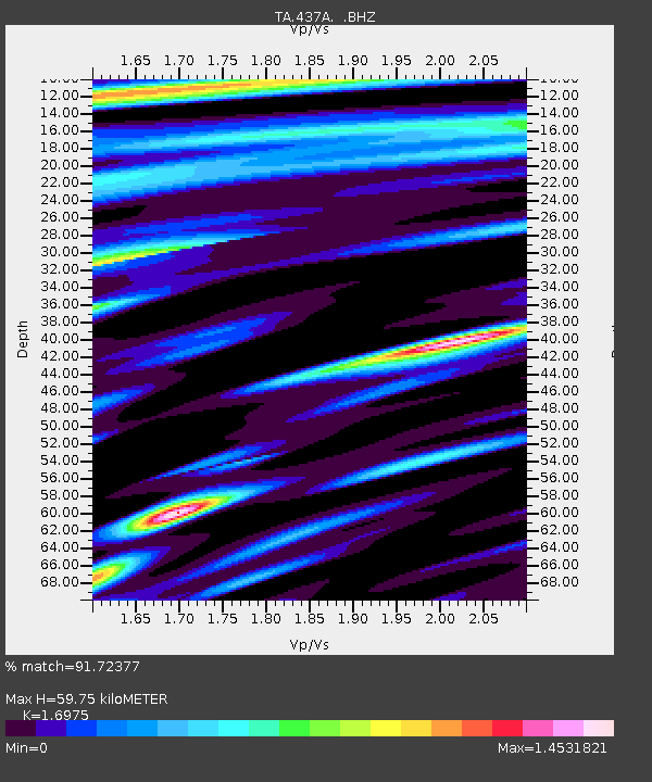
| Estimated Moho Depth: |
59.75 km |
| Estimated Crust Vp/Vs: |
1.70 |
| Assumed Crust Vp: |
6.347 km/s |
| Estimated Crust Vs: |
3.739 km/s |
| Estimated Crust Poisson's Ratio: |
0.23 |
|
| Radial Match: |
91.72377 % |
| Radial Bump: |
400 |
| Transverse Match: |
84.35457 % |
| Transverse Bump: |
400 |
| SOD ConfigId: |
401841 |
| Insert Time: |
2011-12-21 03:42:41.742 +0000 |
| GWidth: |
2.5 |
| Max Bumps: |
400 |
| Tol: |
0.001 |
|
Signal To Noise
| Channel | StoN | STA | LTA |
| TA:437A: :BHZ:20110716T20:07:42.949998Z | 7.374571 | 1.2404037E-6 | 1.6820012E-7 |
| TA:437A: :BHN:20110716T20:07:42.949998Z | 1.0023308 | 4.4757653E-7 | 4.4653578E-7 |
| TA:437A: :BHE:20110716T20:07:42.949998Z | 1.5470747 | 4.3486625E-7 | 2.8108937E-7 |
| Arrivals |
| Ps | 7.0 SECOND |
| PpPs | 24 SECOND |
| PsPs/PpSs | 31 SECOND |


