You are here: Home > Network List > TA - USArray Transportable Network (new EarthScope stations) Stations List
> Station X35A Drake, OK, USA > Earthquake Result Viewer
X35A Drake, OK, USA - Earthquake Result Viewer

| Earthquake location: |
Alaska Peninsula |
| Earthquake latitude/longitude: |
54.8/-161.3 |
| Earthquake time(UTC): |
2011/07/16 (197) 19:59:12 GMT |
| Earthquake Depth: |
36 km |
| Earthquake Magnitude: |
6.3 MB, 5.9 MS, 6.2 MW, 6.1 MW |
| Earthquake Catalog/Contributor: |
WHDF/NEIC |
|
| Network: |
TA USArray Transportable Network (new EarthScope stations) |
| Station: |
X35A Drake, OK, USA |
| Lat/Lon: |
34.40 N/96.97 W |
| Elevation: |
300 m |
|
| Distance: |
48.2 deg |
| Az: |
87.419 deg |
| Baz: |
315.593 deg |
| Ray Param: |
0.06941517 |
| Estimated Moho Depth: |
19.75 km |
| Estimated Crust Vp/Vs: |
2.10 |
| Assumed Crust Vp: |
6.426 km/s |
| Estimated Crust Vs: |
3.064 km/s |
| Estimated Crust Poisson's Ratio: |
0.35 |
|
| Radial Match: |
89.323555 % |
| Radial Bump: |
400 |
| Transverse Match: |
72.60273 % |
| Transverse Bump: |
400 |
| SOD ConfigId: |
401841 |
| Insert Time: |
2011-12-21 03:44:55.065 +0000 |
| GWidth: |
2.5 |
| Max Bumps: |
400 |
| Tol: |
0.001 |
|
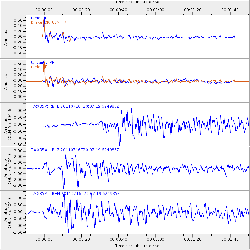
Signal To Noise
| Channel | StoN | STA | LTA |
| TA:X35A: :BHZ:20110716T20:07:19.624985Z | 13.818087 | 6.9336426E-7 | 5.017802E-8 |
| TA:X35A: :BHN:20110716T20:07:19.624985Z | 1.4100221 | 3.083431E-7 | 2.1867962E-7 |
| TA:X35A: :BHE:20110716T20:07:19.624985Z | 3.1066182 | 2.610098E-7 | 8.401734E-8 |
| Arrivals |
| Ps | 3.5 SECOND |
| PpPs | 9.0 SECOND |
| PsPs/PpSs | 13 SECOND |


