You are here: Home > Network List > TA - USArray Transportable Network (new EarthScope stations) Stations List
> Station Y35A Marietta, OK, USA > Earthquake Result Viewer
Y35A Marietta, OK, USA - Earthquake Result Viewer
| Earthquake location: |
Alaska Peninsula |
| Earthquake latitude/longitude: |
54.8/-161.3 |
| Earthquake time(UTC): |
2011/07/16 (197) 19:59:12 GMT |
| Earthquake Depth: |
36 km |
| Earthquake Magnitude: |
6.3 MB, 5.9 MS, 6.2 MW, 6.1 MW |
| Earthquake Catalog/Contributor: |
WHDF/NEIC |
|
| Network: |
TA USArray Transportable Network (new EarthScope stations) |
| Station: |
Y35A Marietta, OK, USA |
| Lat/Lon: |
33.91 N/97.04 W |
| Elevation: |
214 m |
|
| Distance: |
48.6 deg |
| Az: |
87.929 deg |
| Baz: |
315.896 deg |
| Ray Param: |
0.06920697 |
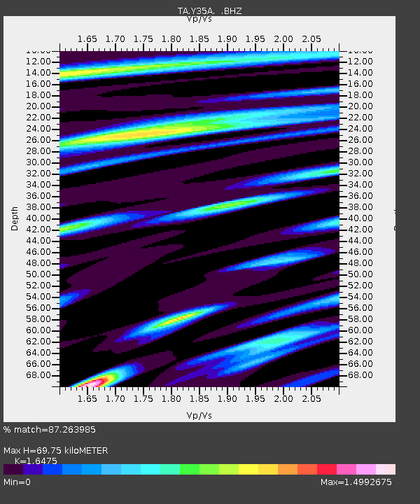
| Estimated Moho Depth: |
69.75 km |
| Estimated Crust Vp/Vs: |
1.65 |
| Assumed Crust Vp: |
6.38 km/s |
| Estimated Crust Vs: |
3.873 km/s |
| Estimated Crust Poisson's Ratio: |
0.21 |
|
| Radial Match: |
87.263985 % |
| Radial Bump: |
400 |
| Transverse Match: |
80.40086 % |
| Transverse Bump: |
400 |
| SOD ConfigId: |
401841 |
| Insert Time: |
2011-12-21 03:45:29.433 +0000 |
| GWidth: |
2.5 |
| Max Bumps: |
400 |
| Tol: |
0.001 |
|
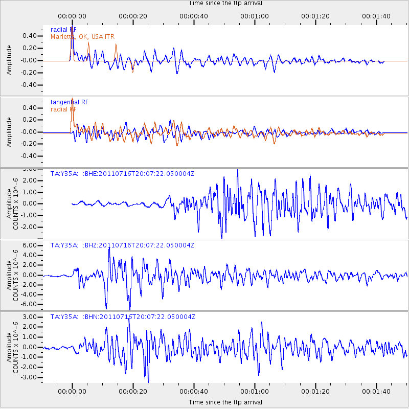
Signal To Noise
| Channel | StoN | STA | LTA |
| TA:Y35A: :BHZ:20110716T20:07:22.050004Z | 12.215434 | 1.1567877E-6 | 9.4698855E-8 |
| TA:Y35A: :BHN:20110716T20:07:22.050004Z | 4.019428 | 4.0647956E-7 | 1.0112871E-7 |
| TA:Y35A: :BHE:20110716T20:07:22.050004Z | 4.5080028 | 5.1526666E-7 | 1.14300434E-7 |
| Arrivals |
| Ps | 7.5 SECOND |
| PpPs | 27 SECOND |
| PsPs/PpSs | 35 SECOND |


