You are here: Home > Network List > TA - USArray Transportable Network (new EarthScope stations) Stations List
> Station Z37A Pogue Cattle Company, Sulphur Springs, TX, USA > Earthquake Result Viewer
Z37A Pogue Cattle Company, Sulphur Springs, TX, USA - Earthquake Result Viewer
| Earthquake location: |
Alaska Peninsula |
| Earthquake latitude/longitude: |
54.8/-161.3 |
| Earthquake time(UTC): |
2011/07/16 (197) 19:59:12 GMT |
| Earthquake Depth: |
36 km |
| Earthquake Magnitude: |
6.3 MB, 5.9 MS, 6.2 MW, 6.1 MW |
| Earthquake Catalog/Contributor: |
WHDF/NEIC |
|
| Network: |
TA USArray Transportable Network (new EarthScope stations) |
| Station: |
Z37A Pogue Cattle Company, Sulphur Springs, TX, USA |
| Lat/Lon: |
33.20 N/95.62 W |
| Elevation: |
146 m |
|
| Distance: |
49.9 deg |
| Az: |
87.451 deg |
| Baz: |
316.361 deg |
| Ray Param: |
0.068345666 |
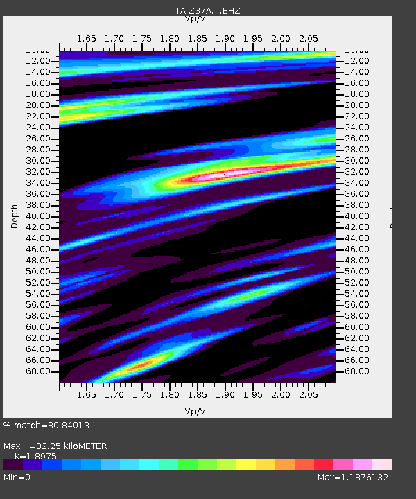
| Estimated Moho Depth: |
32.25 km |
| Estimated Crust Vp/Vs: |
1.90 |
| Assumed Crust Vp: |
6.245 km/s |
| Estimated Crust Vs: |
3.291 km/s |
| Estimated Crust Poisson's Ratio: |
0.31 |
|
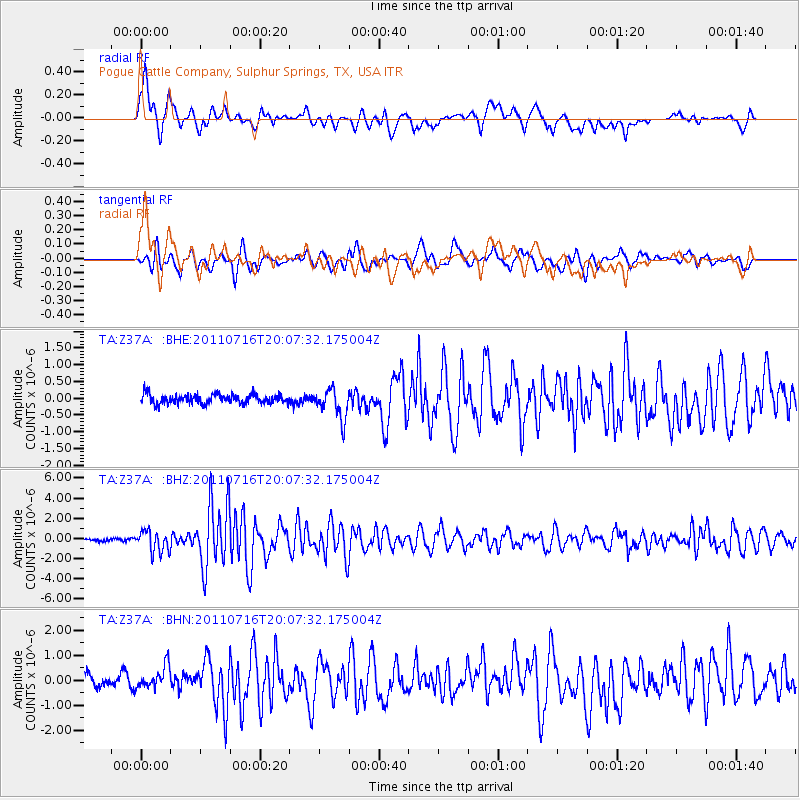
| Radial Match: |
80.84013 % |
| Radial Bump: |
400 |
| Transverse Match: |
81.00337 % |
| Transverse Bump: |
400 |
| SOD ConfigId: |
401841 |
| Insert Time: |
2011-12-21 03:45:47.477 +0000 |
| GWidth: |
2.5 |
| Max Bumps: |
400 |
| Tol: |
0.001 |
|
Signal To Noise
| Channel | StoN | STA | LTA |
| TA:Z37A: :BHZ:20110716T20:07:32.175004Z | 9.061127 | 1.0413121E-6 | 1.1492082E-7 |
| TA:Z37A: :BHN:20110716T20:07:32.175004Z | 2.101644 | 4.3258092E-7 | 2.0582978E-7 |
| TA:Z37A: :BHE:20110716T20:07:32.175004Z | 3.2264042 | 4.4353735E-7 | 1.374711E-7 |
| Arrivals |
| Ps | 4.9 SECOND |
| PpPs | 14 SECOND |
| PsPs/PpSs | 19 SECOND |


