You are here: Home > Network List > TA - USArray Transportable Network (new EarthScope stations) Stations List
> Station Y38A Idabel, OK, USA > Earthquake Result Viewer
Y38A Idabel, OK, USA - Earthquake Result Viewer
| Earthquake location: |
Alaska Peninsula |
| Earthquake latitude/longitude: |
54.8/-161.3 |
| Earthquake time(UTC): |
2011/07/16 (197) 19:59:12 GMT |
| Earthquake Depth: |
36 km |
| Earthquake Magnitude: |
6.3 MB, 5.9 MS, 6.2 MW, 6.1 MW |
| Earthquake Catalog/Contributor: |
WHDF/NEIC |
|
| Network: |
TA USArray Transportable Network (new EarthScope stations) |
| Station: |
Y38A Idabel, OK, USA |
| Lat/Lon: |
33.93 N/94.73 W |
| Elevation: |
118 m |
|
| Distance: |
49.9 deg |
| Az: |
86.089 deg |
| Baz: |
315.975 deg |
| Ray Param: |
0.06835156 |
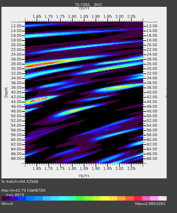
| Estimated Moho Depth: |
42.75 km |
| Estimated Crust Vp/Vs: |
1.66 |
| Assumed Crust Vp: |
6.245 km/s |
| Estimated Crust Vs: |
3.768 km/s |
| Estimated Crust Poisson's Ratio: |
0.21 |
|
| Radial Match: |
84.42586 % |
| Radial Bump: |
400 |
| Transverse Match: |
70.63554 % |
| Transverse Bump: |
400 |
| SOD ConfigId: |
401841 |
| Insert Time: |
2011-12-21 03:46:04.700 +0000 |
| GWidth: |
2.5 |
| Max Bumps: |
400 |
| Tol: |
0.001 |
|
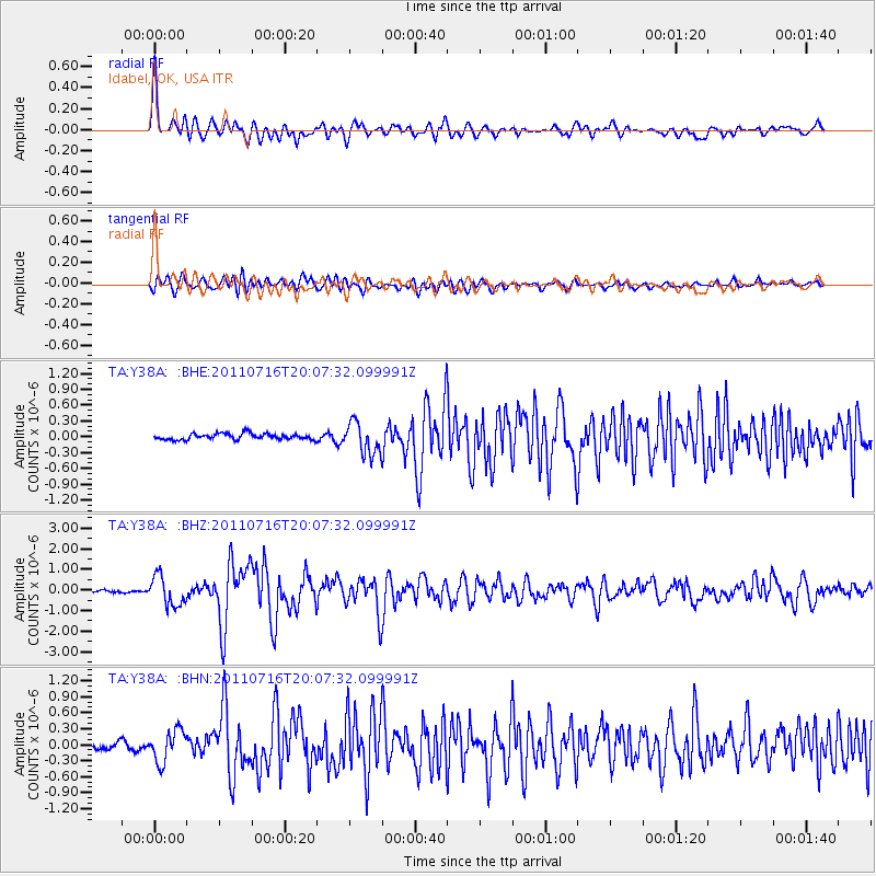
Signal To Noise
| Channel | StoN | STA | LTA |
| TA:Y38A: :BHZ:20110716T20:07:32.099991Z | 9.222574 | 7.1604916E-7 | 7.764093E-8 |
| TA:Y38A: :BHN:20110716T20:07:32.099991Z | 2.8189096 | 2.9684767E-7 | 1.05305844E-7 |
| TA:Y38A: :BHE:20110716T20:07:32.099991Z | 5.36323 | 3.0150485E-7 | 5.6217026E-8 |
| Arrivals |
| Ps | 4.8 SECOND |
| PpPs | 17 SECOND |
| PsPs/PpSs | 22 SECOND |


