You are here: Home > Network List > TA - USArray Transportable Network (new EarthScope stations) Stations List
> Station P34A Walnut Farm, Randolph, KS, USA > Earthquake Result Viewer
P34A Walnut Farm, Randolph, KS, USA - Earthquake Result Viewer
| Earthquake location: |
Alaska Peninsula |
| Earthquake latitude/longitude: |
54.8/-161.3 |
| Earthquake time(UTC): |
2011/07/16 (197) 19:59:12 GMT |
| Earthquake Depth: |
36 km |
| Earthquake Magnitude: |
6.3 MB, 5.9 MS, 6.2 MW, 6.1 MW |
| Earthquake Catalog/Contributor: |
WHDF/NEIC |
|
| Network: |
TA USArray Transportable Network (new EarthScope stations) |
| Station: |
P34A Walnut Farm, Randolph, KS, USA |
| Lat/Lon: |
39.55 N/96.83 W |
| Elevation: |
429 m |
|
| Distance: |
44.8 deg |
| Az: |
82.198 deg |
| Baz: |
312.084 deg |
| Ray Param: |
0.0716428 |
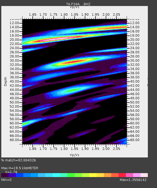
| Estimated Moho Depth: |
19.5 km |
| Estimated Crust Vp/Vs: |
1.76 |
| Assumed Crust Vp: |
6.483 km/s |
| Estimated Crust Vs: |
3.683 km/s |
| Estimated Crust Poisson's Ratio: |
0.26 |
|
| Radial Match: |
92.884026 % |
| Radial Bump: |
395 |
| Transverse Match: |
73.51377 % |
| Transverse Bump: |
400 |
| SOD ConfigId: |
401841 |
| Insert Time: |
2011-12-21 03:48:02.496 +0000 |
| GWidth: |
2.5 |
| Max Bumps: |
400 |
| Tol: |
0.001 |
|

Signal To Noise
| Channel | StoN | STA | LTA |
| TA:P34A: :BHZ:20110716T20:06:52.40001Z | 10.635454 | 7.783172E-7 | 7.318138E-8 |
| TA:P34A: :BHN:20110716T20:06:52.40001Z | 4.7532907 | 3.7119236E-7 | 7.809166E-8 |
| TA:P34A: :BHE:20110716T20:06:52.40001Z | 6.7605853 | 4.066446E-7 | 6.014932E-8 |
| Arrivals |
| Ps | 2.4 SECOND |
| PpPs | 7.8 SECOND |
| PsPs/PpSs | 10 SECOND |


