You are here: Home > Network List > TA - USArray Transportable Network (new EarthScope stations) Stations List
> Station M34A Aspy Farms, Fremont, NE, USA > Earthquake Result Viewer
M34A Aspy Farms, Fremont, NE, USA - Earthquake Result Viewer
| Earthquake location: |
Alaska Peninsula |
| Earthquake latitude/longitude: |
54.8/-161.3 |
| Earthquake time(UTC): |
2011/07/16 (197) 19:59:12 GMT |
| Earthquake Depth: |
36 km |
| Earthquake Magnitude: |
6.3 MB, 5.9 MS, 6.2 MW, 6.1 MW |
| Earthquake Catalog/Contributor: |
WHDF/NEIC |
|
| Network: |
TA USArray Transportable Network (new EarthScope stations) |
| Station: |
M34A Aspy Farms, Fremont, NE, USA |
| Lat/Lon: |
41.50 N/96.58 W |
| Elevation: |
415 m |
|
| Distance: |
43.6 deg |
| Az: |
79.918 deg |
| Baz: |
310.606 deg |
| Ray Param: |
0.07236057 |
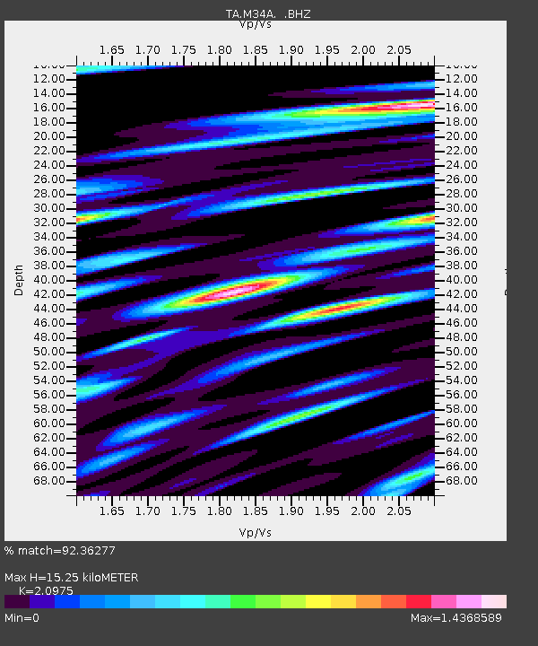
| Estimated Moho Depth: |
15.25 km |
| Estimated Crust Vp/Vs: |
2.10 |
| Assumed Crust Vp: |
6.498 km/s |
| Estimated Crust Vs: |
3.098 km/s |
| Estimated Crust Poisson's Ratio: |
0.35 |
|
| Radial Match: |
92.36277 % |
| Radial Bump: |
400 |
| Transverse Match: |
74.38541 % |
| Transverse Bump: |
400 |
| SOD ConfigId: |
401841 |
| Insert Time: |
2011-12-21 03:48:17.576 +0000 |
| GWidth: |
2.5 |
| Max Bumps: |
400 |
| Tol: |
0.001 |
|

Signal To Noise
| Channel | StoN | STA | LTA |
| TA:M34A: :BHZ:20110716T20:06:43.224991Z | 8.922097 | 1.1261488E-6 | 1.262202E-7 |
| TA:M34A: :BHN:20110716T20:06:43.224991Z | 3.6344714 | 6.940025E-7 | 1.9095006E-7 |
| TA:M34A: :BHE:20110716T20:06:43.224991Z | 3.022873 | 6.358505E-7 | 2.1034641E-7 |
| Arrivals |
| Ps | 2.7 SECOND |
| PpPs | 6.9 SECOND |
| PsPs/PpSs | 9.6 SECOND |


