You are here: Home > Network List > TA - USArray Transportable Network (new EarthScope stations) Stations List
> Station L35A Bielow Farm, Ricketts, IA, USA > Earthquake Result Viewer
L35A Bielow Farm, Ricketts, IA, USA - Earthquake Result Viewer
| Earthquake location: |
Alaska Peninsula |
| Earthquake latitude/longitude: |
54.8/-161.3 |
| Earthquake time(UTC): |
2011/07/16 (197) 19:59:12 GMT |
| Earthquake Depth: |
36 km |
| Earthquake Magnitude: |
6.3 MB, 5.9 MS, 6.2 MW, 6.1 MW |
| Earthquake Catalog/Contributor: |
WHDF/NEIC |
|
| Network: |
TA USArray Transportable Network (new EarthScope stations) |
| Station: |
L35A Bielow Farm, Ricketts, IA, USA |
| Lat/Lon: |
42.11 N/95.54 W |
| Elevation: |
410 m |
|
| Distance: |
43.8 deg |
| Az: |
78.518 deg |
| Baz: |
310.284 deg |
| Ray Param: |
0.07223281 |
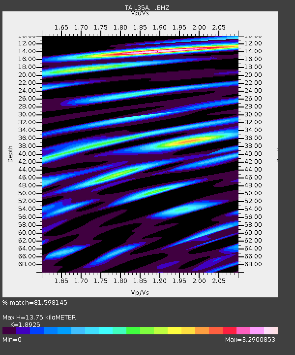
| Estimated Moho Depth: |
13.75 km |
| Estimated Crust Vp/Vs: |
1.89 |
| Assumed Crust Vp: |
6.53 km/s |
| Estimated Crust Vs: |
3.451 km/s |
| Estimated Crust Poisson's Ratio: |
0.31 |
|
| Radial Match: |
81.598145 % |
| Radial Bump: |
400 |
| Transverse Match: |
74.988396 % |
| Transverse Bump: |
400 |
| SOD ConfigId: |
401841 |
| Insert Time: |
2011-12-21 03:48:37.114 +0000 |
| GWidth: |
2.5 |
| Max Bumps: |
400 |
| Tol: |
0.001 |
|

Signal To Noise
| Channel | StoN | STA | LTA |
| TA:L35A: :BHZ:20110716T20:06:44.77501Z | 9.634454 | 8.568022E-7 | 8.893106E-8 |
| TA:L35A: :BHN:20110716T20:06:44.77501Z | 4.938087 | 5.6008486E-7 | 1.1342142E-7 |
| TA:L35A: :BHE:20110716T20:06:44.77501Z | 3.2376847 | 4.405111E-7 | 1.3605744E-7 |
| Arrivals |
| Ps | 2.0 SECOND |
| PpPs | 5.7 SECOND |
| PsPs/PpSs | 7.7 SECOND |


