You are here: Home > Network List > TA - USArray Transportable Network (new EarthScope stations) Stations List
> Station V36A Jenks, OK, USA > Earthquake Result Viewer
V36A Jenks, OK, USA - Earthquake Result Viewer
| Earthquake location: |
Alaska Peninsula |
| Earthquake latitude/longitude: |
54.8/-161.3 |
| Earthquake time(UTC): |
2011/07/16 (197) 19:59:12 GMT |
| Earthquake Depth: |
36 km |
| Earthquake Magnitude: |
6.3 MB, 5.9 MS, 6.2 MW, 6.1 MW |
| Earthquake Catalog/Contributor: |
WHDF/NEIC |
|
| Network: |
TA USArray Transportable Network (new EarthScope stations) |
| Station: |
V36A Jenks, OK, USA |
| Lat/Lon: |
35.79 N/95.94 W |
| Elevation: |
236 m |
|
| Distance: |
47.9 deg |
| Az: |
85.301 deg |
| Baz: |
314.767 deg |
| Ray Param: |
0.06965479 |
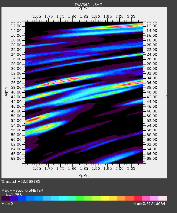
| Estimated Moho Depth: |
35.0 km |
| Estimated Crust Vp/Vs: |
1.75 |
| Assumed Crust Vp: |
6.498 km/s |
| Estimated Crust Vs: |
3.702 km/s |
| Estimated Crust Poisson's Ratio: |
0.26 |
|
| Radial Match: |
92.968185 % |
| Radial Bump: |
400 |
| Transverse Match: |
82.50561 % |
| Transverse Bump: |
400 |
| SOD ConfigId: |
401841 |
| Insert Time: |
2011-12-21 03:48:53.681 +0000 |
| GWidth: |
2.5 |
| Max Bumps: |
400 |
| Tol: |
0.001 |
|
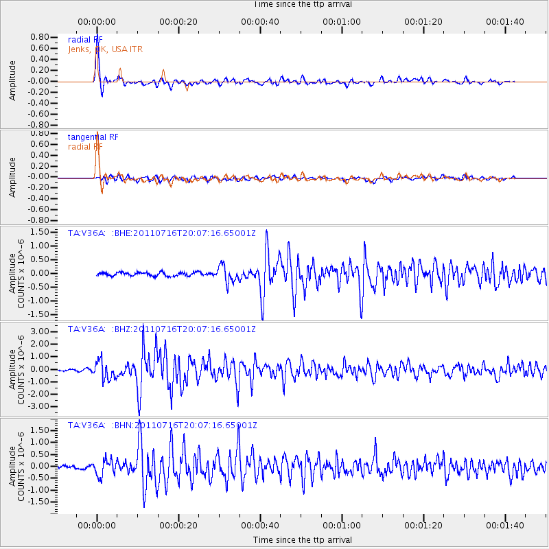
Signal To Noise
| Channel | StoN | STA | LTA |
| TA:V36A: :BHZ:20110716T20:07:16.65001Z | 11.9728155 | 7.2335786E-7 | 6.041668E-8 |
| TA:V36A: :BHN:20110716T20:07:16.65001Z | 4.549661 | 3.4307294E-7 | 7.540626E-8 |
| TA:V36A: :BHE:20110716T20:07:16.65001Z | 4.5901737 | 2.9895355E-7 | 6.512903E-8 |
| Arrivals |
| Ps | 4.3 SECOND |
| PpPs | 14 SECOND |
| PsPs/PpSs | 18 SECOND |


