You are here: Home > Network List > TA - USArray Transportable Network (new EarthScope stations) Stations List
> Station U36A Oologah, OK, USA > Earthquake Result Viewer
U36A Oologah, OK, USA - Earthquake Result Viewer
| Earthquake location: |
Alaska Peninsula |
| Earthquake latitude/longitude: |
54.8/-161.3 |
| Earthquake time(UTC): |
2011/07/16 (197) 19:59:12 GMT |
| Earthquake Depth: |
36 km |
| Earthquake Magnitude: |
6.3 MB, 5.9 MS, 6.2 MW, 6.1 MW |
| Earthquake Catalog/Contributor: |
WHDF/NEIC |
|
| Network: |
TA USArray Transportable Network (new EarthScope stations) |
| Station: |
U36A Oologah, OK, USA |
| Lat/Lon: |
36.39 N/95.73 W |
| Elevation: |
187 m |
|
| Distance: |
47.6 deg |
| Az: |
84.557 deg |
| Baz: |
314.389 deg |
| Ray Param: |
0.0698434 |
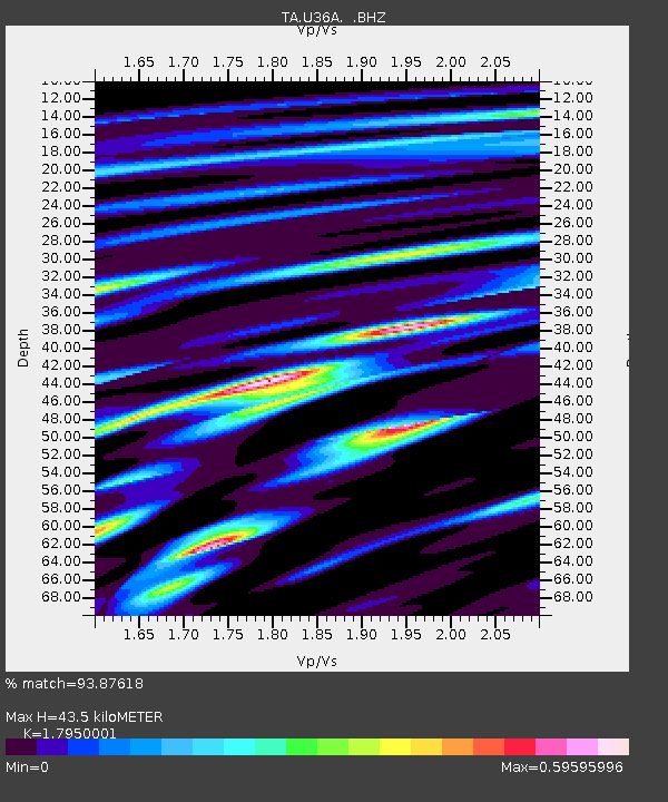
| Estimated Moho Depth: |
43.5 km |
| Estimated Crust Vp/Vs: |
1.80 |
| Assumed Crust Vp: |
6.53 km/s |
| Estimated Crust Vs: |
3.638 km/s |
| Estimated Crust Poisson's Ratio: |
0.27 |
|
| Radial Match: |
93.87618 % |
| Radial Bump: |
384 |
| Transverse Match: |
78.70651 % |
| Transverse Bump: |
400 |
| SOD ConfigId: |
401841 |
| Insert Time: |
2011-12-21 03:49:59.888 +0000 |
| GWidth: |
2.5 |
| Max Bumps: |
400 |
| Tol: |
0.001 |
|

Signal To Noise
| Channel | StoN | STA | LTA |
| TA:U36A: :BHZ:20110716T20:07:14.300004Z | 9.631966 | 8.392232E-7 | 8.712897E-8 |
| TA:U36A: :BHN:20110716T20:07:14.300004Z | 3.5248525 | 3.1293615E-7 | 8.8779935E-8 |
| TA:U36A: :BHE:20110716T20:07:14.300004Z | 4.6094217 | 3.5273058E-7 | 7.6523825E-8 |
| Arrivals |
| Ps | 5.6 SECOND |
| PpPs | 17 SECOND |
| PsPs/PpSs | 23 SECOND |


