You are here: Home > Network List > TA - USArray Transportable Network (new EarthScope stations) Stations List
> Station K31A O'Neill, NE, USA > Earthquake Result Viewer
K31A O'Neill, NE, USA - Earthquake Result Viewer
| Earthquake location: |
Alaska Peninsula |
| Earthquake latitude/longitude: |
54.8/-161.3 |
| Earthquake time(UTC): |
2011/07/16 (197) 19:59:12 GMT |
| Earthquake Depth: |
36 km |
| Earthquake Magnitude: |
6.3 MB, 5.9 MS, 6.2 MW, 6.1 MW |
| Earthquake Catalog/Contributor: |
WHDF/NEIC |
|
| Network: |
TA USArray Transportable Network (new EarthScope stations) |
| Station: |
K31A O'Neill, NE, USA |
| Lat/Lon: |
42.62 N/98.75 W |
| Elevation: |
580 m |
|
| Distance: |
41.7 deg |
| Az: |
80.185 deg |
| Baz: |
309.353 deg |
| Ray Param: |
0.07357696 |
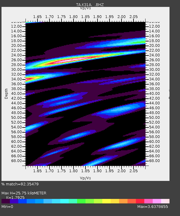
| Estimated Moho Depth: |
25.75 km |
| Estimated Crust Vp/Vs: |
1.79 |
| Assumed Crust Vp: |
6.53 km/s |
| Estimated Crust Vs: |
3.643 km/s |
| Estimated Crust Poisson's Ratio: |
0.27 |
|
| Radial Match: |
92.35479 % |
| Radial Bump: |
286 |
| Transverse Match: |
85.439926 % |
| Transverse Bump: |
400 |
| SOD ConfigId: |
401841 |
| Insert Time: |
2011-12-21 03:53:05.240 +0000 |
| GWidth: |
2.5 |
| Max Bumps: |
400 |
| Tol: |
0.001 |
|
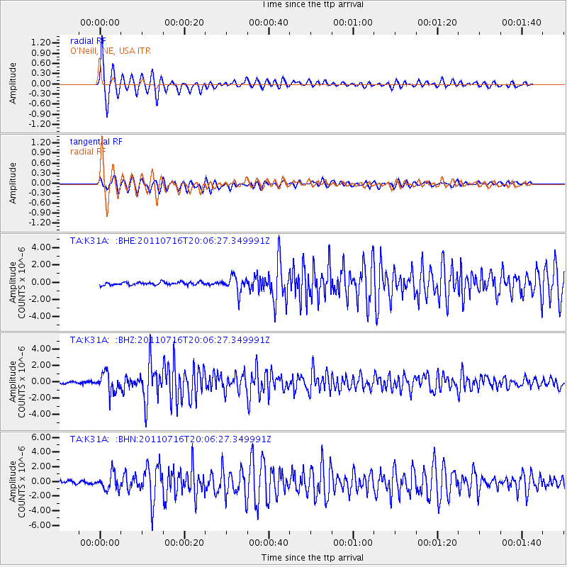
Signal To Noise
| Channel | StoN | STA | LTA |
| TA:K31A: :BHZ:20110716T20:06:27.349991Z | 11.442078 | 1.1715479E-6 | 1.02389436E-7 |
| TA:K31A: :BHN:20110716T20:06:27.349991Z | 5.827077 | 1.1105152E-6 | 1.9057843E-7 |
| TA:K31A: :BHE:20110716T20:06:27.349991Z | 5.7389197 | 9.3995516E-7 | 1.6378607E-7 |
| Arrivals |
| Ps | 3.4 SECOND |
| PpPs | 10 SECOND |
| PsPs/PpSs | 14 SECOND |


