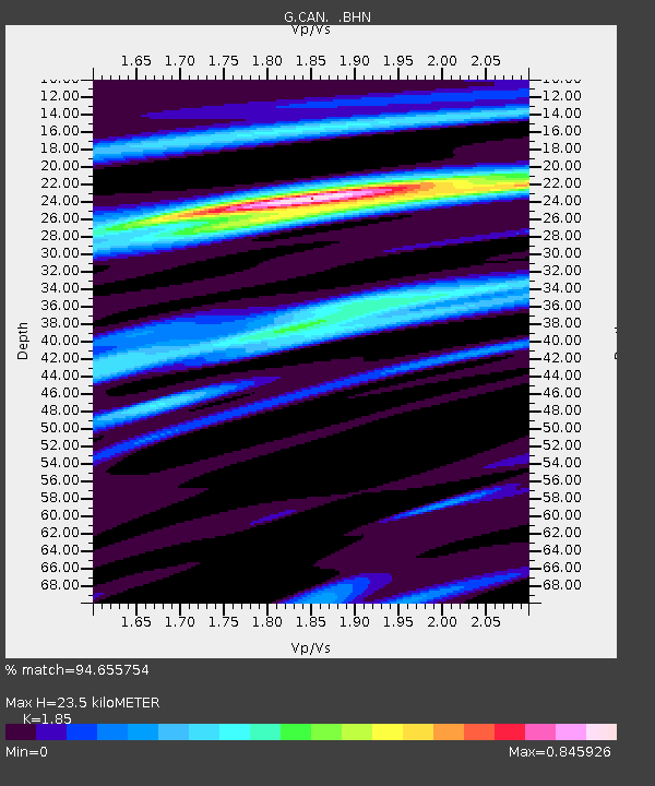
CAN Canberra, Australia - Earthquake Result Viewer

Earthquake location: Southern Sumatra, Indonesia
Earthquake latitude/longitude: -4.6/101.9
Earthquake time(UTC): 2000/06/07 (159) 23:45:26 GMT
Earthquake Depth: 33 km
Earthquake Magnitude: 6.1 MB, 6.7 MS, 6.7 MW, 6.5 MW
Earthquake Catalog/Contributor: WHDF/NEIC
Network: G GEOSCOPE
Station: CAN Canberra, Australia
Lat/Lon: 35.32 S/149.00 E
Elevation: 650 m
Distance: 53.1 deg
Az: 131.464 deg
Baz: 294.013 deg
Ray Param: 0.06628751
Estimated Moho Depth: 23.5 km
Estimated Crust Vp/Vs: 1.85
Assumed Crust Vp: 6.633 km/s
Estimated Crust Vs: 3.586 km/s
Estimated Crust Poisson's Ratio: 0.29
Radial Match: 94.655754 %
Radial Bump: 309
Transverse Match: 69.99065 %
Transverse Bump: 400
SOD ConfigId: 3744
Insert Time: 2010-02-26 21:44:15.332 +0000
GWidth: 2.5
Max Bumps: 400
Tol: 0.001

Signal To Noise

ChannelStoNSTALTA
G:CAN: :BHN:20000607T23:54:10.049019Z2.9092266.195244E-72.1295163E-7
G:CAN: :BHE:20000607T23:54:10.049019Z3.43123469.2631143E-72.6996446E-7
G:CAN: :BHZ:20000607T23:54:10.049019Z7.47073132.3927043E-63.202771E-7
Arrivals
Ps3.2 SECOND
PpPs9.5 SECOND
PsPs/PpSs13 SECOND