You are here: Home > Network List > TA - USArray Transportable Network (new EarthScope stations) Stations List
> Station C31A Landman Farms, Northwood, ND, USA > Earthquake Result Viewer
C31A Landman Farms, Northwood, ND, USA - Earthquake Result Viewer
| Earthquake location: |
Alaska Peninsula |
| Earthquake latitude/longitude: |
54.8/-161.3 |
| Earthquake time(UTC): |
2011/07/16 (197) 19:59:12 GMT |
| Earthquake Depth: |
36 km |
| Earthquake Magnitude: |
6.3 MB, 5.9 MS, 6.2 MW, 6.1 MW |
| Earthquake Catalog/Contributor: |
WHDF/NEIC |
|
| Network: |
TA USArray Transportable Network (new EarthScope stations) |
| Station: |
C31A Landman Farms, Northwood, ND, USA |
| Lat/Lon: |
47.79 N/97.73 W |
| Elevation: |
384 m |
|
| Distance: |
39.1 deg |
| Az: |
73.142 deg |
| Baz: |
304.707 deg |
| Ray Param: |
0.07509882 |
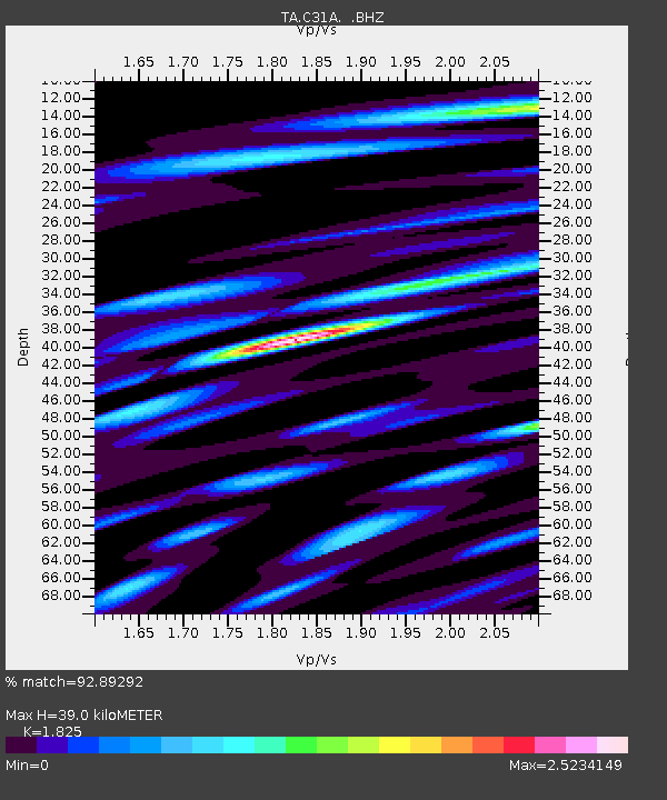
| Estimated Moho Depth: |
39.0 km |
| Estimated Crust Vp/Vs: |
1.83 |
| Assumed Crust Vp: |
6.498 km/s |
| Estimated Crust Vs: |
3.56 km/s |
| Estimated Crust Poisson's Ratio: |
0.29 |
|
| Radial Match: |
92.89292 % |
| Radial Bump: |
400 |
| Transverse Match: |
84.55053 % |
| Transverse Bump: |
400 |
| SOD ConfigId: |
401841 |
| Insert Time: |
2011-12-21 03:53:24.745 +0000 |
| GWidth: |
2.5 |
| Max Bumps: |
400 |
| Tol: |
0.001 |
|
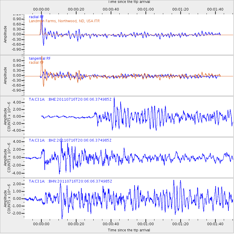
Signal To Noise
| Channel | StoN | STA | LTA |
| TA:C31A: :BHZ:20110716T20:06:06.374985Z | 8.756434 | 1.3063067E-6 | 1.491825E-7 |
| TA:C31A: :BHN:20110716T20:06:06.374985Z | 3.2592921 | 4.915953E-7 | 1.5082885E-7 |
| TA:C31A: :BHE:20110716T20:06:06.374985Z | 5.057999 | 9.00702E-7 | 1.7807476E-7 |
| Arrivals |
| Ps | 5.3 SECOND |
| PpPs | 16 SECOND |
| PsPs/PpSs | 21 SECOND |


