You are here: Home > Network List > TA - USArray Transportable Network (new EarthScope stations) Stations List
> Station F34A Alexandria, MN, USA > Earthquake Result Viewer
F34A Alexandria, MN, USA - Earthquake Result Viewer
| Earthquake location: |
Alaska Peninsula |
| Earthquake latitude/longitude: |
54.8/-161.3 |
| Earthquake time(UTC): |
2011/07/16 (197) 19:59:12 GMT |
| Earthquake Depth: |
36 km |
| Earthquake Magnitude: |
6.3 MB, 5.9 MS, 6.2 MW, 6.1 MW |
| Earthquake Catalog/Contributor: |
WHDF/NEIC |
|
| Network: |
TA USArray Transportable Network (new EarthScope stations) |
| Station: |
F34A Alexandria, MN, USA |
| Lat/Lon: |
45.80 N/95.26 W |
| Elevation: |
419 m |
|
| Distance: |
41.7 deg |
| Az: |
74.095 deg |
| Baz: |
307.233 deg |
| Ray Param: |
0.07357133 |
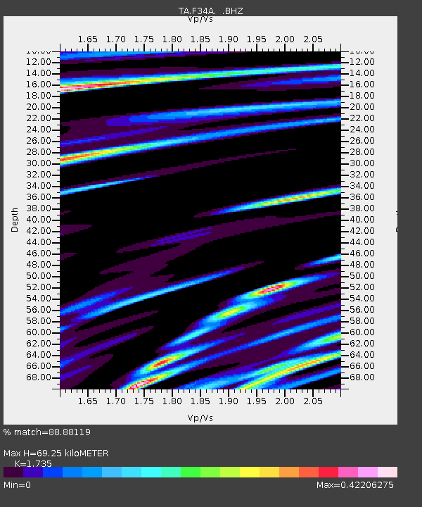
| Estimated Moho Depth: |
69.25 km |
| Estimated Crust Vp/Vs: |
1.74 |
| Assumed Crust Vp: |
6.571 km/s |
| Estimated Crust Vs: |
3.787 km/s |
| Estimated Crust Poisson's Ratio: |
0.25 |
|
| Radial Match: |
88.88119 % |
| Radial Bump: |
400 |
| Transverse Match: |
73.013115 % |
| Transverse Bump: |
400 |
| SOD ConfigId: |
401841 |
| Insert Time: |
2011-12-21 03:55:03.523 +0000 |
| GWidth: |
2.5 |
| Max Bumps: |
400 |
| Tol: |
0.001 |
|
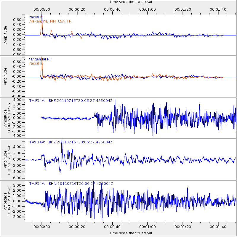
Signal To Noise
| Channel | StoN | STA | LTA |
| TA:F34A: :BHZ:20110716T20:06:27.425004Z | 20.282604 | 1.2266233E-6 | 6.0476616E-8 |
| TA:F34A: :BHN:20110716T20:06:27.425004Z | 5.079338 | 9.99952E-7 | 1.9686658E-7 |
| TA:F34A: :BHE:20110716T20:06:27.425004Z | 8.907797 | 9.609444E-7 | 1.0787677E-7 |
| Arrivals |
| Ps | 8.3 SECOND |
| PpPs | 27 SECOND |
| PsPs/PpSs | 35 SECOND |


