You are here: Home > Network List > TA - USArray Transportable Network (new EarthScope stations) Stations List
> Station B35A Bob, Littlefork, MN, USA > Earthquake Result Viewer
B35A Bob, Littlefork, MN, USA - Earthquake Result Viewer
| Earthquake location: |
Alaska Peninsula |
| Earthquake latitude/longitude: |
54.8/-161.3 |
| Earthquake time(UTC): |
2011/07/16 (197) 19:59:12 GMT |
| Earthquake Depth: |
36 km |
| Earthquake Magnitude: |
6.3 MB, 5.9 MS, 6.2 MW, 6.1 MW |
| Earthquake Catalog/Contributor: |
WHDF/NEIC |
|
| Network: |
TA USArray Transportable Network (new EarthScope stations) |
| Station: |
B35A Bob, Littlefork, MN, USA |
| Lat/Lon: |
48.36 N/93.73 W |
| Elevation: |
358 m |
|
| Distance: |
41.0 deg |
| Az: |
70.024 deg |
| Baz: |
305.293 deg |
| Ray Param: |
0.07399537 |
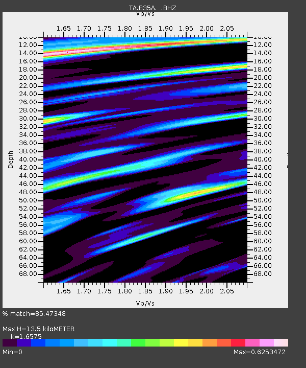
| Estimated Moho Depth: |
13.5 km |
| Estimated Crust Vp/Vs: |
1.66 |
| Assumed Crust Vp: |
6.419 km/s |
| Estimated Crust Vs: |
3.873 km/s |
| Estimated Crust Poisson's Ratio: |
0.21 |
|
| Radial Match: |
85.47348 % |
| Radial Bump: |
400 |
| Transverse Match: |
56.721695 % |
| Transverse Bump: |
400 |
| SOD ConfigId: |
401841 |
| Insert Time: |
2011-12-21 03:57:49.006 +0000 |
| GWidth: |
2.5 |
| Max Bumps: |
400 |
| Tol: |
0.001 |
|

Signal To Noise
| Channel | StoN | STA | LTA |
| TA:B35A: :BHZ:20110716T20:06:21.90001Z | 15.877329 | 1.4147221E-6 | 8.9103274E-8 |
| TA:B35A: :BHN:20110716T20:06:21.90001Z | 3.3396487 | 5.1854545E-7 | 1.5526946E-7 |
| TA:B35A: :BHE:20110716T20:06:21.90001Z | 4.8154855 | 6.6818137E-7 | 1.387568E-7 |
| Arrivals |
| Ps | 1.5 SECOND |
| PpPs | 5.2 SECOND |
| PsPs/PpSs | 6.7 SECOND |


