You are here: Home > Network List > TA - USArray Transportable Network (new EarthScope stations) Stations List
> Station O56A Blue Knob State Park, Imler, PA, USA > Earthquake Result Viewer
O56A Blue Knob State Park, Imler, PA, USA - Earthquake Result Viewer
| Earthquake location: |
Alaska Peninsula |
| Earthquake latitude/longitude: |
54.8/-161.3 |
| Earthquake time(UTC): |
2011/07/16 (197) 19:59:12 GMT |
| Earthquake Depth: |
36 km |
| Earthquake Magnitude: |
6.3 MB, 5.9 MS, 6.2 MW, 6.1 MW |
| Earthquake Catalog/Contributor: |
WHDF/NEIC |
|
| Network: |
TA USArray Transportable Network (new EarthScope stations) |
| Station: |
O56A Blue Knob State Park, Imler, PA, USA |
| Lat/Lon: |
40.27 N/78.57 W |
| Elevation: |
684 m |
|
| Distance: |
54.5 deg |
| Az: |
68.832 deg |
| Baz: |
315.098 deg |
| Ray Param: |
0.06535477 |
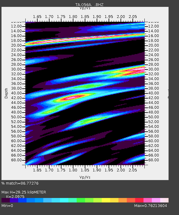
| Estimated Moho Depth: |
29.25 km |
| Estimated Crust Vp/Vs: |
2.10 |
| Assumed Crust Vp: |
6.121 km/s |
| Estimated Crust Vs: |
2.918 km/s |
| Estimated Crust Poisson's Ratio: |
0.35 |
|
| Radial Match: |
86.77276 % |
| Radial Bump: |
400 |
| Transverse Match: |
79.63102 % |
| Transverse Bump: |
400 |
| SOD ConfigId: |
401841 |
| Insert Time: |
2011-12-21 03:58:54.167 +0000 |
| GWidth: |
2.5 |
| Max Bumps: |
400 |
| Tol: |
0.001 |
|
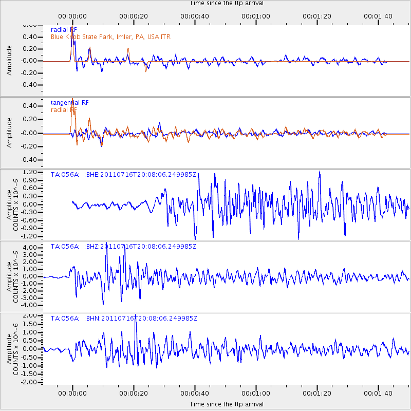
Signal To Noise
| Channel | StoN | STA | LTA |
| TA:O56A: :BHZ:20110716T20:08:06.249985Z | 13.55924 | 1.1281468E-6 | 8.320133E-8 |
| TA:O56A: :BHN:20110716T20:08:06.249985Z | 3.6424203 | 3.9655376E-7 | 1.0887095E-7 |
| TA:O56A: :BHE:20110716T20:08:06.249985Z | 5.730541 | 4.3463817E-7 | 7.584592E-8 |
| Arrivals |
| Ps | 5.5 SECOND |
| PpPs | 14 SECOND |
| PsPs/PpSs | 20 SECOND |


