You are here: Home > Network List > TA - USArray Transportable Network (new EarthScope stations) Stations List
> Station J61A Chester, VT, USA > Earthquake Result Viewer
J61A Chester, VT, USA - Earthquake Result Viewer

| Earthquake location: |
Near Coast Of Nicaragua |
| Earthquake latitude/longitude: |
11.6/-86.6 |
| Earthquake time(UTC): |
2014/03/28 (087) 14:36:08 GMT |
| Earthquake Depth: |
46 km |
| Earthquake Magnitude: |
5.6 MWW, 5.5 MWB, 5.6 MWC |
| Earthquake Catalog/Contributor: |
NEIC PDE/NEIC COMCAT |
|
| Network: |
TA USArray Transportable Network (new EarthScope stations) |
| Station: |
J61A Chester, VT, USA |
| Lat/Lon: |
43.35 N/72.55 W |
| Elevation: |
253 m |
|
| Distance: |
33.8 deg |
| Az: |
18.481 deg |
| Baz: |
205.194 deg |
| Ray Param: |
0.07793018 |
| Estimated Moho Depth: |
15.25 km |
| Estimated Crust Vp/Vs: |
1.60 |
| Assumed Crust Vp: |
6.419 km/s |
| Estimated Crust Vs: |
4.012 km/s |
| Estimated Crust Poisson's Ratio: |
0.18 |
|
| Radial Match: |
85.4989 % |
| Radial Bump: |
400 |
| Transverse Match: |
61.39847 % |
| Transverse Bump: |
395 |
| SOD ConfigId: |
3390531 |
| Insert Time: |
2019-04-10 22:30:06.476 +0000 |
| GWidth: |
2.5 |
| Max Bumps: |
400 |
| Tol: |
0.001 |
|
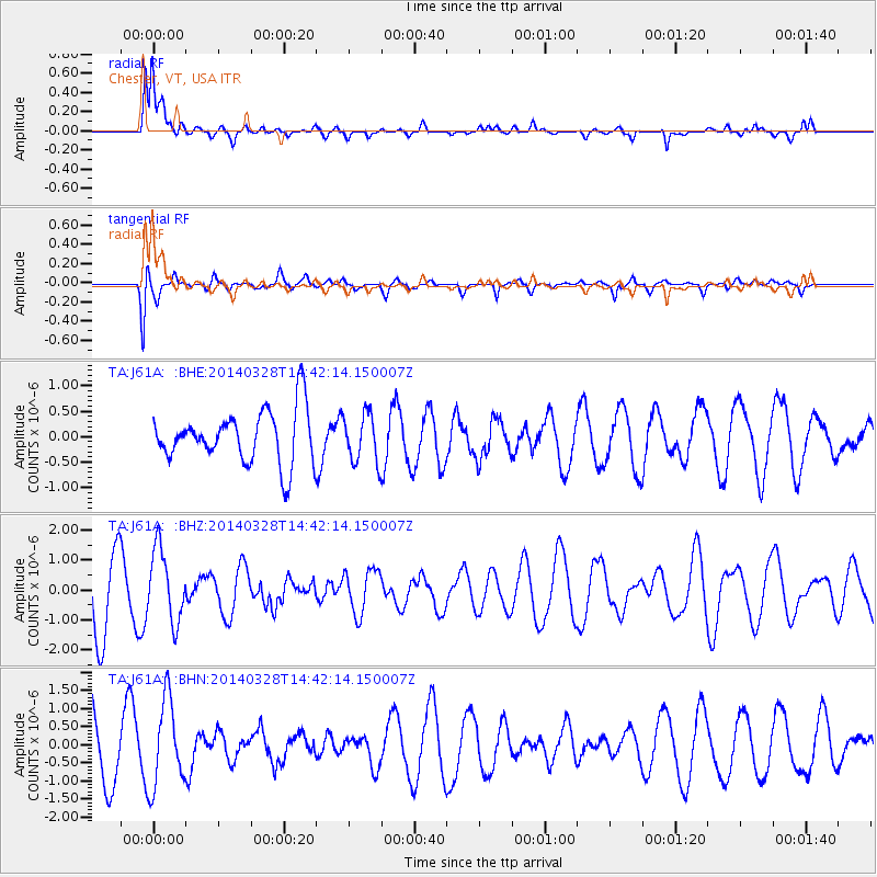
Signal To Noise
| Channel | StoN | STA | LTA |
| TA:J61A: :BHZ:20140328T14:42:14.150007Z | 1.1233523 | 1.1939865E-6 | 1.062878E-6 |
| TA:J61A: :BHN:20140328T14:42:14.150007Z | 1.2813075 | 1.1965473E-6 | 9.338487E-7 |
| TA:J61A: :BHE:20140328T14:42:14.150007Z | 0.9981642 | 5.3709704E-7 | 5.3808486E-7 |
| Arrivals |
| Ps | 1.6 SECOND |
| PpPs | 5.7 SECOND |
| PsPs/PpSs | 7.2 SECOND |


