You are here: Home > Network List > TA - USArray Transportable Network (new EarthScope stations) Stations List
> Station P40A Paris, MO, USA > Earthquake Result Viewer
P40A Paris, MO, USA - Earthquake Result Viewer

| Earthquake location: |
Alaska Peninsula |
| Earthquake latitude/longitude: |
54.8/-161.3 |
| Earthquake time(UTC): |
2011/07/16 (197) 19:59:12 GMT |
| Earthquake Depth: |
36 km |
| Earthquake Magnitude: |
6.3 MB, 5.9 MS, 6.2 MW, 6.1 MW |
| Earthquake Catalog/Contributor: |
WHDF/NEIC |
|
| Network: |
TA USArray Transportable Network (new EarthScope stations) |
| Station: |
P40A Paris, MO, USA |
| Lat/Lon: |
39.53 N/92.05 W |
| Elevation: |
225 m |
|
| Distance: |
47.5 deg |
| Az: |
78.759 deg |
| Baz: |
312.731 deg |
| Ray Param: |
0.06987266 |
| Estimated Moho Depth: |
46.5 km |
| Estimated Crust Vp/Vs: |
1.72 |
| Assumed Crust Vp: |
6.498 km/s |
| Estimated Crust Vs: |
3.772 km/s |
| Estimated Crust Poisson's Ratio: |
0.25 |
|
| Radial Match: |
90.768036 % |
| Radial Bump: |
400 |
| Transverse Match: |
81.22818 % |
| Transverse Bump: |
400 |
| SOD ConfigId: |
401841 |
| Insert Time: |
2011-12-21 04:02:03.579 +0000 |
| GWidth: |
2.5 |
| Max Bumps: |
400 |
| Tol: |
0.001 |
|
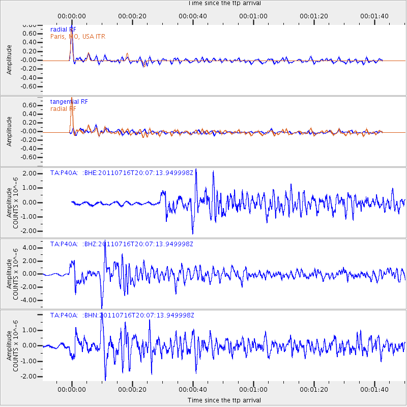
Signal To Noise
| Channel | StoN | STA | LTA |
| TA:P40A: :BHZ:20110716T20:07:13.949998Z | 15.708929 | 1.3467467E-6 | 8.573129E-8 |
| TA:P40A: :BHN:20110716T20:07:13.949998Z | 7.7646823 | 5.250198E-7 | 6.761639E-8 |
| TA:P40A: :BHE:20110716T20:07:13.949998Z | 6.8735747 | 5.687975E-7 | 8.2751335E-8 |
| Arrivals |
| Ps | 5.5 SECOND |
| PpPs | 18 SECOND |
| PsPs/PpSs | 24 SECOND |


