You are here: Home > Network List > TA - USArray Transportable Network (new EarthScope stations) Stations List
> Station S40A Lebanon, MO, USA > Earthquake Result Viewer
S40A Lebanon, MO, USA - Earthquake Result Viewer

| Earthquake location: |
Alaska Peninsula |
| Earthquake latitude/longitude: |
54.8/-161.3 |
| Earthquake time(UTC): |
2011/07/16 (197) 19:59:12 GMT |
| Earthquake Depth: |
36 km |
| Earthquake Magnitude: |
6.3 MB, 5.9 MS, 6.2 MW, 6.1 MW |
| Earthquake Catalog/Contributor: |
WHDF/NEIC |
|
| Network: |
TA USArray Transportable Network (new EarthScope stations) |
| Station: |
S40A Lebanon, MO, USA |
| Lat/Lon: |
37.60 N/92.50 W |
| Elevation: |
336 m |
|
| Distance: |
48.6 deg |
| Az: |
80.973 deg |
| Baz: |
313.93 deg |
| Ray Param: |
0.069198266 |
| Estimated Moho Depth: |
39.5 km |
| Estimated Crust Vp/Vs: |
1.97 |
| Assumed Crust Vp: |
6.53 km/s |
| Estimated Crust Vs: |
3.315 km/s |
| Estimated Crust Poisson's Ratio: |
0.33 |
|
| Radial Match: |
86.65108 % |
| Radial Bump: |
400 |
| Transverse Match: |
66.221214 % |
| Transverse Bump: |
400 |
| SOD ConfigId: |
401841 |
| Insert Time: |
2011-12-21 04:02:19.030 +0000 |
| GWidth: |
2.5 |
| Max Bumps: |
400 |
| Tol: |
0.001 |
|
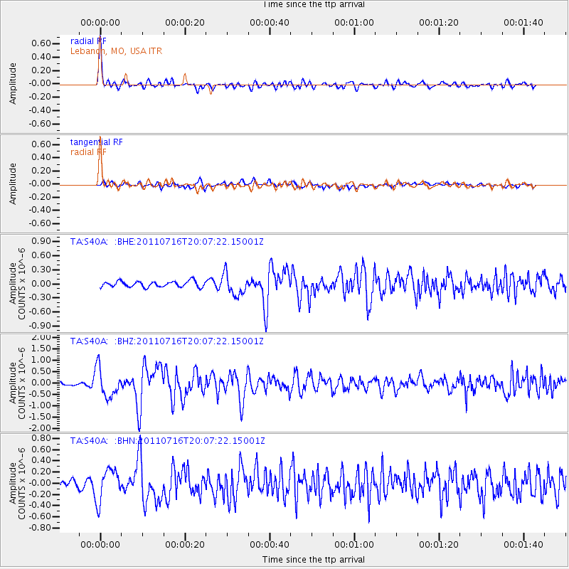
Signal To Noise
| Channel | StoN | STA | LTA |
| TA:S40A: :BHZ:20110716T20:07:22.15001Z | 7.95064 | 6.362305E-7 | 8.0022545E-8 |
| TA:S40A: :BHN:20110716T20:07:22.15001Z | 4.0052924 | 2.8882653E-7 | 7.211122E-8 |
| TA:S40A: :BHE:20110716T20:07:22.15001Z | 3.813714 | 2.324121E-7 | 6.094115E-8 |
| Arrivals |
| Ps | 6.2 SECOND |
| PpPs | 17 SECOND |
| PsPs/PpSs | 23 SECOND |


