You are here: Home > Network List > TA - USArray Transportable Network (new EarthScope stations) Stations List
> Station 142A Monroe, LA, USA > Earthquake Result Viewer
142A Monroe, LA, USA - Earthquake Result Viewer
| Earthquake location: |
Alaska Peninsula |
| Earthquake latitude/longitude: |
54.8/-161.3 |
| Earthquake time(UTC): |
2011/07/16 (197) 19:59:12 GMT |
| Earthquake Depth: |
36 km |
| Earthquake Magnitude: |
6.3 MB, 5.9 MS, 6.2 MW, 6.1 MW |
| Earthquake Catalog/Contributor: |
WHDF/NEIC |
|
| Network: |
TA USArray Transportable Network (new EarthScope stations) |
| Station: |
142A Monroe, LA, USA |
| Lat/Lon: |
32.55 N/91.95 W |
| Elevation: |
23 m |
|
| Distance: |
52.5 deg |
| Az: |
85.134 deg |
| Baz: |
316.896 deg |
| Ray Param: |
0.066663206 |
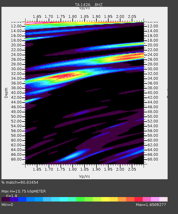
| Estimated Moho Depth: |
10.75 km |
| Estimated Crust Vp/Vs: |
1.60 |
| Assumed Crust Vp: |
6.201 km/s |
| Estimated Crust Vs: |
3.876 km/s |
| Estimated Crust Poisson's Ratio: |
0.18 |
|
| Radial Match: |
90.83454 % |
| Radial Bump: |
400 |
| Transverse Match: |
87.92082 % |
| Transverse Bump: |
400 |
| SOD ConfigId: |
401841 |
| Insert Time: |
2011-12-21 04:05:13.285 +0000 |
| GWidth: |
2.5 |
| Max Bumps: |
400 |
| Tol: |
0.001 |
|

Signal To Noise
| Channel | StoN | STA | LTA |
| TA:142A: :BHZ:20110716T20:07:51.600022Z | 6.5740123 | 1.4936977E-6 | 2.272125E-7 |
| TA:142A: :BHN:20110716T20:07:51.600022Z | 1.7679245 | 6.439794E-7 | 3.6425726E-7 |
| TA:142A: :BHE:20110716T20:07:51.600022Z | 2.2292516 | 5.8677193E-7 | 2.6321473E-7 |
| Arrivals |
| Ps | 1.1 SECOND |
| PpPs | 4.3 SECOND |
| PsPs/PpSs | 5.4 SECOND |


