You are here: Home > Network List > TA - USArray Transportable Network (new EarthScope stations) Stations List
> Station Y44A Strider, Charleston, MS, USA > Earthquake Result Viewer
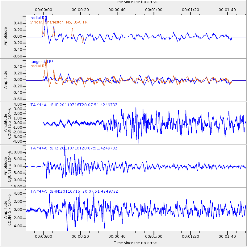
Y44A Strider, Charleston, MS, USA - Earthquake Result Viewer
*The percent match for this event was below the threshold and hence no stack was calculated.
| Earthquake location: |
Alaska Peninsula |
| Earthquake latitude/longitude: |
54.8/-161.3 |
| Earthquake time(UTC): |
2011/07/16 (197) 19:59:12 GMT |
| Earthquake Depth: |
36 km |
| Earthquake Magnitude: |
6.3 MB, 5.9 MS, 6.2 MW, 6.1 MW |
| Earthquake Catalog/Contributor: |
WHDF/NEIC |
|
| Network: |
TA USArray Transportable Network (new EarthScope stations) |
| Station: |
Y44A Strider, Charleston, MS, USA |
| Lat/Lon: |
33.96 N/90.21 W |
| Elevation: |
46 m |
|
| Distance: |
52.5 deg |
| Az: |
82.582 deg |
| Baz: |
316.287 deg |
| Ray Param: |
$rayparam |
*The percent match for this event was below the threshold and hence was not used in the summary stack. |
|
| Radial Match: |
82.63028 % |
| Radial Bump: |
400 |
| Transverse Match: |
81.81547 % |
| Transverse Bump: |
400 |
| SOD ConfigId: |
401841 |
| Insert Time: |
2011-12-21 04:08:54.974 +0000 |
| GWidth: |
2.5 |
| Max Bumps: |
400 |
| Tol: |
0.001 |
|
Signal To Noise
| Channel | StoN | STA | LTA |
| TA:Y44A: :BHZ:20110716T20:07:51.424973Z | 13.286848 | 2.752187E-6 | 2.0713617E-7 |
| TA:Y44A: :BHN:20110716T20:07:51.424973Z | 3.8932662 | 1.1306747E-6 | 2.9041803E-7 |
| TA:Y44A: :BHE:20110716T20:07:51.424973Z | 1.9945929 | 6.008901E-7 | 3.0125952E-7 |
| Arrivals |
| Ps | |
| PpPs | |
| PsPs/PpSs | |


