You are here: Home > Network List > US - United States National Seismic Network Stations List
> Station DGMT Dagmar, Montana, USA > Earthquake Result Viewer
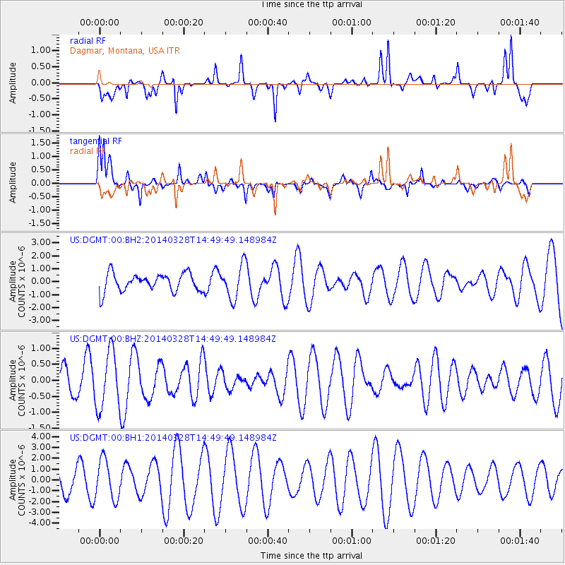
DGMT Dagmar, Montana, USA - Earthquake Result Viewer
*The percent match for this event was below the threshold and hence no stack was calculated.
| Earthquake location: |
Fiji Islands Region |
| Earthquake latitude/longitude: |
-17.2/-176.7 |
| Earthquake time(UTC): |
2014/03/28 (087) 14:37:13 GMT |
| Earthquake Depth: |
10 km |
| Earthquake Magnitude: |
5.6 MW |
| Earthquake Catalog/Contributor: |
ISC/ISC |
|
| Network: |
US United States National Seismic Network |
| Station: |
DGMT Dagmar, Montana, USA |
| Lat/Lon: |
48.47 N/104.20 W |
| Elevation: |
0.0 m |
|
| Distance: |
91.6 deg |
| Az: |
39.409 deg |
| Baz: |
245.742 deg |
| Ray Param: |
$rayparam |
*The percent match for this event was below the threshold and hence was not used in the summary stack. |
|
| Radial Match: |
70.997986 % |
| Radial Bump: |
391 |
| Transverse Match: |
65.62966 % |
| Transverse Bump: |
300 |
| SOD ConfigId: |
3390531 |
| Insert Time: |
2019-04-10 22:35:23.155 +0000 |
| GWidth: |
2.5 |
| Max Bumps: |
400 |
| Tol: |
0.001 |
|
Signal To Noise
| Channel | StoN | STA | LTA |
| US:DGMT:00:BHZ:20140328T14:49:49.148984Z | 3.2640822 | 9.0568994E-7 | 2.7747154E-7 |
| US:DGMT:00:BH1:20140328T14:49:49.148984Z | 2.7537234 | 1.8471673E-6 | 6.7078895E-7 |
| US:DGMT:00:BH2:20140328T14:49:49.148984Z | 1.95769 | 1.3511631E-6 | 6.9018233E-7 |
| Arrivals |
| Ps | |
| PpPs | |
| PsPs/PpSs | |


