You are here: Home > Network List > TA - USArray Transportable Network (new EarthScope stations) Stations List
> Station V45A Humboldt, TN, USA > Earthquake Result Viewer
V45A Humboldt, TN, USA - Earthquake Result Viewer
| Earthquake location: |
Alaska Peninsula |
| Earthquake latitude/longitude: |
54.8/-161.3 |
| Earthquake time(UTC): |
2011/07/16 (197) 19:59:12 GMT |
| Earthquake Depth: |
36 km |
| Earthquake Magnitude: |
6.3 MB, 5.9 MS, 6.2 MW, 6.1 MW |
| Earthquake Catalog/Contributor: |
WHDF/NEIC |
|
| Network: |
TA USArray Transportable Network (new EarthScope stations) |
| Station: |
V45A Humboldt, TN, USA |
| Lat/Lon: |
35.74 N/88.96 W |
| Elevation: |
126 m |
|
| Distance: |
51.9 deg |
| Az: |
80.082 deg |
| Baz: |
315.467 deg |
| Ray Param: |
0.0670379 |
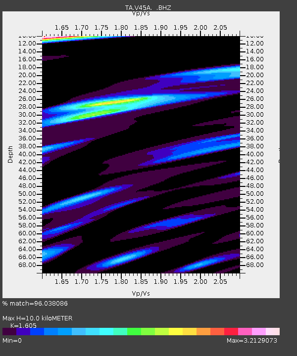
| Estimated Moho Depth: |
10.0 km |
| Estimated Crust Vp/Vs: |
1.61 |
| Assumed Crust Vp: |
6.38 km/s |
| Estimated Crust Vs: |
3.975 km/s |
| Estimated Crust Poisson's Ratio: |
0.18 |
|
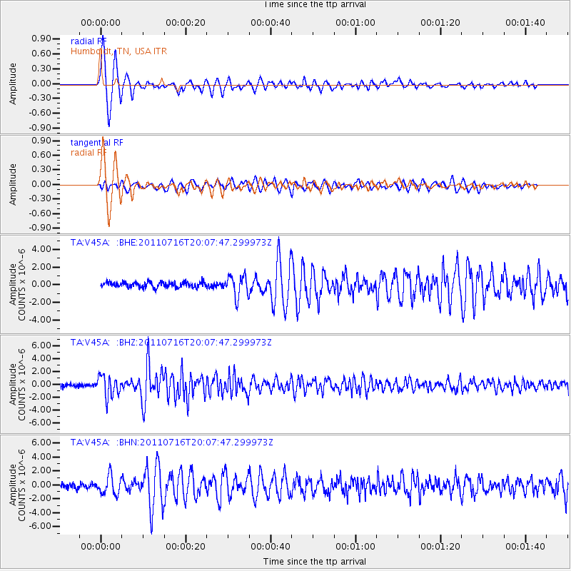
| Radial Match: |
96.038086 % |
| Radial Bump: |
342 |
| Transverse Match: |
81.29841 % |
| Transverse Bump: |
400 |
| SOD ConfigId: |
401841 |
| Insert Time: |
2011-12-21 04:11:12.573 +0000 |
| GWidth: |
2.5 |
| Max Bumps: |
400 |
| Tol: |
0.001 |
|
Signal To Noise
| Channel | StoN | STA | LTA |
| TA:V45A: :BHZ:20110716T20:07:47.299973Z | 9.196195 | 1.6282025E-6 | 1.7705176E-7 |
| TA:V45A: :BHN:20110716T20:07:47.299973Z | 3.3243108 | 1.3744854E-6 | 4.1346476E-7 |
| TA:V45A: :BHE:20110716T20:07:47.299973Z | 3.9144301 | 1.2028403E-6 | 3.072836E-7 |
| Arrivals |
| Ps | 1.0 SECOND |
| PpPs | 3.8 SECOND |
| PsPs/PpSs | 4.8 SECOND |


