You are here: Home > Network List > TA - USArray Transportable Network (new EarthScope stations) Stations List
> Station U42A Revenden, AR, USA > Earthquake Result Viewer
U42A Revenden, AR, USA - Earthquake Result Viewer
| Earthquake location: |
Alaska Peninsula |
| Earthquake latitude/longitude: |
54.8/-161.3 |
| Earthquake time(UTC): |
2011/07/16 (197) 19:59:12 GMT |
| Earthquake Depth: |
36 km |
| Earthquake Magnitude: |
6.3 MB, 5.9 MS, 6.2 MW, 6.1 MW |
| Earthquake Catalog/Contributor: |
WHDF/NEIC |
|
| Network: |
TA USArray Transportable Network (new EarthScope stations) |
| Station: |
U42A Revenden, AR, USA |
| Lat/Lon: |
36.35 N/91.24 W |
| Elevation: |
119 m |
|
| Distance: |
50.2 deg |
| Az: |
81.213 deg |
| Baz: |
314.843 deg |
| Ray Param: |
0.068166725 |
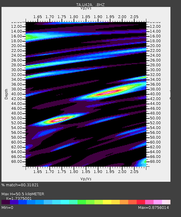
| Estimated Moho Depth: |
50.5 km |
| Estimated Crust Vp/Vs: |
1.74 |
| Assumed Crust Vp: |
6.53 km/s |
| Estimated Crust Vs: |
3.759 km/s |
| Estimated Crust Poisson's Ratio: |
0.25 |
|
| Radial Match: |
80.31821 % |
| Radial Bump: |
400 |
| Transverse Match: |
74.9033 % |
| Transverse Bump: |
400 |
| SOD ConfigId: |
401841 |
| Insert Time: |
2011-12-21 04:13:59.511 +0000 |
| GWidth: |
2.5 |
| Max Bumps: |
400 |
| Tol: |
0.001 |
|
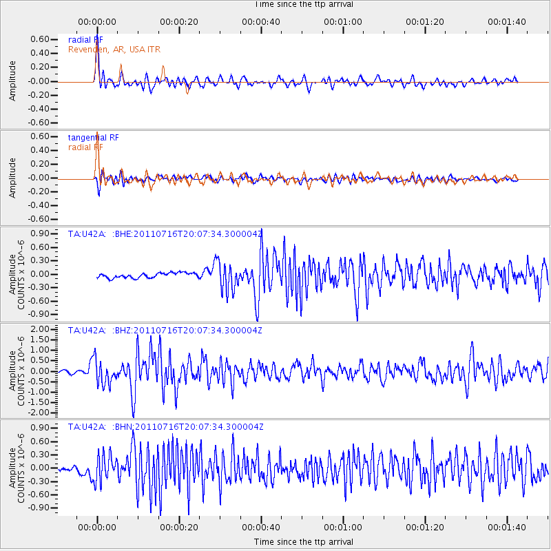
Signal To Noise
| Channel | StoN | STA | LTA |
| TA:U42A: :BHZ:20110716T20:07:34.300004Z | 7.0703835 | 5.6366827E-7 | 7.972245E-8 |
| TA:U42A: :BHN:20110716T20:07:34.300004Z | 4.334735 | 2.9045637E-7 | 6.700672E-8 |
| TA:U42A: :BHE:20110716T20:07:34.300004Z | 5.696076 | 3.150296E-7 | 5.5306426E-8 |
| Arrivals |
| Ps | 6.1 SECOND |
| PpPs | 20 SECOND |
| PsPs/PpSs | 26 SECOND |


