You are here: Home > Network List > KN - Kyrgyz Seismic Telemetry Network Stations List
> Station TKM2 - > Earthquake Result Viewer
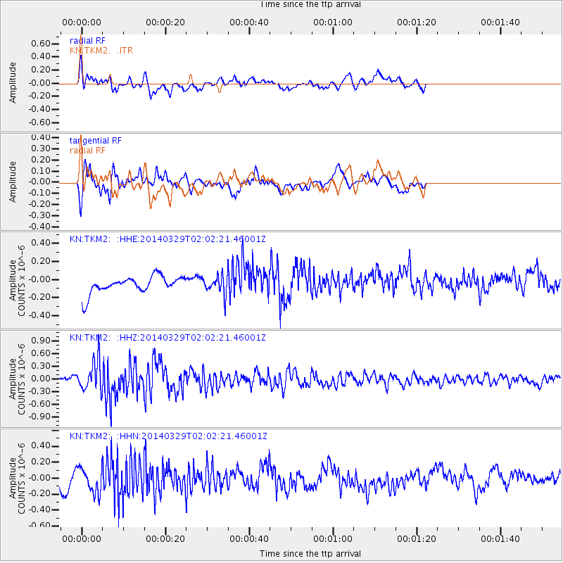
TKM2 - - Earthquake Result Viewer
*The percent match for this event was below the threshold and hence no stack was calculated.
| Earthquake location: |
Near East Coast Of Honshu, Japan |
| Earthquake latitude/longitude: |
36.3/141.8 |
| Earthquake time(UTC): |
2014/03/29 (088) 01:53:57 GMT |
| Earthquake Depth: |
20 km |
| Earthquake Magnitude: |
5.5 MWC, 5.4 MWB, 5.5 MWC |
| Earthquake Catalog/Contributor: |
NEIC PDE/NEIC COMCAT |
|
| Network: |
KN Kyrgyz Seismic Telemetry Network |
| Station: |
TKM2 - |
| Lat/Lon: |
42.92 N/75.60 E |
| Elevation: |
2020 m |
|
| Distance: |
50.3 deg |
| Az: |
299.053 deg |
| Baz: |
73.966 deg |
| Ray Param: |
$rayparam |
*The percent match for this event was below the threshold and hence was not used in the summary stack. |
|
| Radial Match: |
58.80808 % |
| Radial Bump: |
400 |
| Transverse Match: |
54.862957 % |
| Transverse Bump: |
400 |
| SOD ConfigId: |
3390531 |
| Insert Time: |
2019-04-10 22:39:34.109 +0000 |
| GWidth: |
2.5 |
| Max Bumps: |
400 |
| Tol: |
0.001 |
|
Signal To Noise
| Channel | StoN | STA | LTA |
| KN:TKM2: :HHZ:20140329T02:02:21.46001Z | 3.6254115 | 3.5968782E-7 | 9.921297E-8 |
| KN:TKM2: :HHN:20140329T02:02:21.46001Z | 1.9310219 | 1.6068859E-7 | 8.3214275E-8 |
| KN:TKM2: :HHE:20140329T02:02:21.46001Z | 1.2085649 | 1.112588E-7 | 9.2058606E-8 |
| Arrivals |
| Ps | |
| PpPs | |
| PsPs/PpSs | |


