You are here: Home > Network List > CI - Caltech Regional Seismic Network Stations List
> Station MPP McPhearson Peak > Earthquake Result Viewer
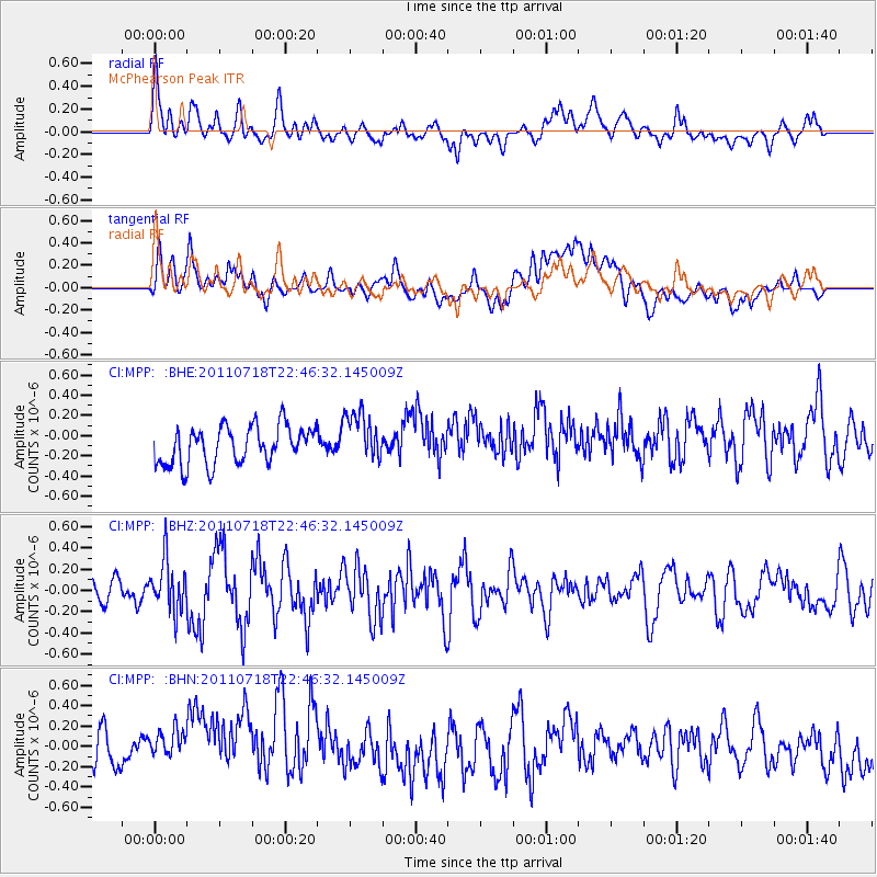
MPP McPhearson Peak - Earthquake Result Viewer
*The percent match for this event was below the threshold and hence no stack was calculated.
| Earthquake location: |
Rat Islands, Aleutian Islands |
| Earthquake latitude/longitude: |
51.3/178.9 |
| Earthquake time(UTC): |
2011/07/18 (199) 22:38:38 GMT |
| Earthquake Depth: |
19 km |
| Earthquake Magnitude: |
5.8 MW, 5.3 MS, 5.4 MB, 5.8 MW |
| Earthquake Catalog/Contributor: |
WHDF/NEIC |
|
| Network: |
CI Caltech Regional Seismic Network |
| Station: |
MPP McPhearson Peak |
| Lat/Lon: |
34.89 N/119.81 W |
| Elevation: |
1739 m |
|
| Distance: |
46.3 deg |
| Az: |
86.042 deg |
| Baz: |
310.342 deg |
| Ray Param: |
$rayparam |
*The percent match for this event was below the threshold and hence was not used in the summary stack. |
|
| Radial Match: |
53.966064 % |
| Radial Bump: |
400 |
| Transverse Match: |
35.093124 % |
| Transverse Bump: |
400 |
| SOD ConfigId: |
401841 |
| Insert Time: |
2011-12-21 04:29:58.598 +0000 |
| GWidth: |
2.5 |
| Max Bumps: |
400 |
| Tol: |
0.001 |
|
Signal To Noise
| Channel | StoN | STA | LTA |
| CI:MPP: :BHZ:20110718T22:46:32.145009Z | 1.7432009 | 2.3959444E-7 | 1.3744511E-7 |
| CI:MPP: :BHN:20110718T22:46:32.145009Z | 1.2785273 | 4.395568E-7 | 3.4379934E-7 |
| CI:MPP: :BHE:20110718T22:46:32.145009Z | 1.3076041 | 2.4412594E-7 | 1.8669714E-7 |
| Arrivals |
| Ps | |
| PpPs | |
| PsPs/PpSs | |


