You are here: Home > Network List > IW - Intermountain West Stations List
> Station MOOW Moose Ponds, Wyoming, USA > Earthquake Result Viewer
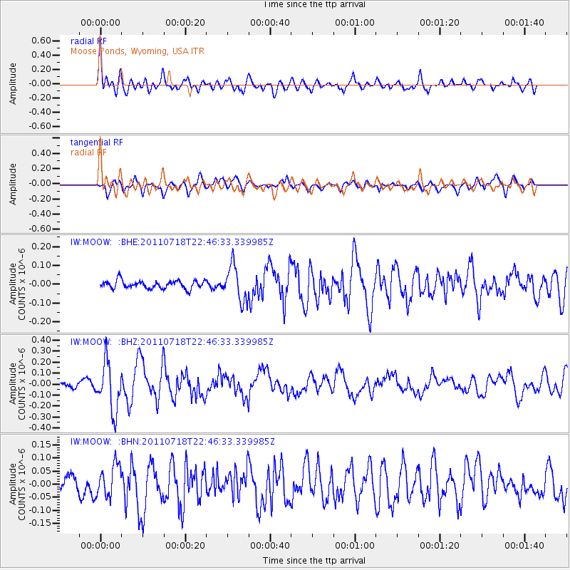
MOOW Moose Ponds, Wyoming, USA - Earthquake Result Viewer
*The percent match for this event was below the threshold and hence no stack was calculated.
| Earthquake location: |
Rat Islands, Aleutian Islands |
| Earthquake latitude/longitude: |
51.3/178.9 |
| Earthquake time(UTC): |
2011/07/18 (199) 22:38:38 GMT |
| Earthquake Depth: |
19 km |
| Earthquake Magnitude: |
5.8 MW, 5.3 MS, 5.4 MB, 5.8 MW |
| Earthquake Catalog/Contributor: |
WHDF/NEIC |
|
| Network: |
IW Intermountain West |
| Station: |
MOOW Moose Ponds, Wyoming, USA |
| Lat/Lon: |
43.75 N/110.74 W |
| Elevation: |
2128 m |
|
| Distance: |
46.4 deg |
| Az: |
70.413 deg |
| Baz: |
305.262 deg |
| Ray Param: |
$rayparam |
*The percent match for this event was below the threshold and hence was not used in the summary stack. |
|
| Radial Match: |
73.12028 % |
| Radial Bump: |
400 |
| Transverse Match: |
65.54048 % |
| Transverse Bump: |
400 |
| SOD ConfigId: |
401841 |
| Insert Time: |
2011-12-21 04:36:03.413 +0000 |
| GWidth: |
2.5 |
| Max Bumps: |
400 |
| Tol: |
0.001 |
|
Signal To Noise
| Channel | StoN | STA | LTA |
| IW:MOOW: :BHZ:20110718T22:46:33.339985Z | 5.2481766 | 2.254459E-7 | 4.2956998E-8 |
| IW:MOOW: :BHN:20110718T22:46:33.339985Z | 1.9071931 | 5.932644E-8 | 3.1106676E-8 |
| IW:MOOW: :BHE:20110718T22:46:33.339985Z | 4.52202 | 9.60447E-8 | 2.1239337E-8 |
| Arrivals |
| Ps | |
| PpPs | |
| PsPs/PpSs | |


