You are here: Home > Network List > TA - USArray Transportable Network (new EarthScope stations) Stations List
> Station R33A Olander Ranch, Little River, KS, USA > Earthquake Result Viewer
R33A Olander Ranch, Little River, KS, USA - Earthquake Result Viewer
| Earthquake location: |
Rat Islands, Aleutian Islands |
| Earthquake latitude/longitude: |
51.3/178.9 |
| Earthquake time(UTC): |
2011/07/18 (199) 22:38:38 GMT |
| Earthquake Depth: |
19 km |
| Earthquake Magnitude: |
5.8 MW, 5.3 MS, 5.4 MB, 5.8 MW |
| Earthquake Catalog/Contributor: |
WHDF/NEIC |
|
| Network: |
TA USArray Transportable Network (new EarthScope stations) |
| Station: |
R33A Olander Ranch, Little River, KS, USA |
| Lat/Lon: |
38.31 N/97.98 W |
| Elevation: |
497 m |
|
| Distance: |
57.3 deg |
| Az: |
68.104 deg |
| Baz: |
312.204 deg |
| Ray Param: |
0.063546665 |
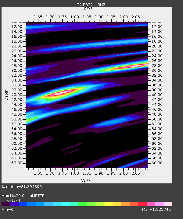
| Estimated Moho Depth: |
39.0 km |
| Estimated Crust Vp/Vs: |
1.74 |
| Assumed Crust Vp: |
6.483 km/s |
| Estimated Crust Vs: |
3.726 km/s |
| Estimated Crust Poisson's Ratio: |
0.25 |
|
| Radial Match: |
81.394806 % |
| Radial Bump: |
310 |
| Transverse Match: |
57.036015 % |
| Transverse Bump: |
400 |
| SOD ConfigId: |
401841 |
| Insert Time: |
2011-12-21 04:48:15.482 +0000 |
| GWidth: |
2.5 |
| Max Bumps: |
400 |
| Tol: |
0.001 |
|

Signal To Noise
| Channel | StoN | STA | LTA |
| TA:R33A: :BHZ:20110718T22:47:54.550007Z | 6.0657153 | 5.600981E-7 | 9.233834E-8 |
| TA:R33A: :BHN:20110718T22:47:54.550007Z | 2.9383662 | 2.737274E-7 | 9.315634E-8 |
| TA:R33A: :BHE:20110718T22:47:54.550007Z | 1.7381519 | 2.039557E-7 | 1.1734054E-7 |
| Arrivals |
| Ps | 4.7 SECOND |
| PpPs | 16 SECOND |
| PsPs/PpSs | 20 SECOND |


