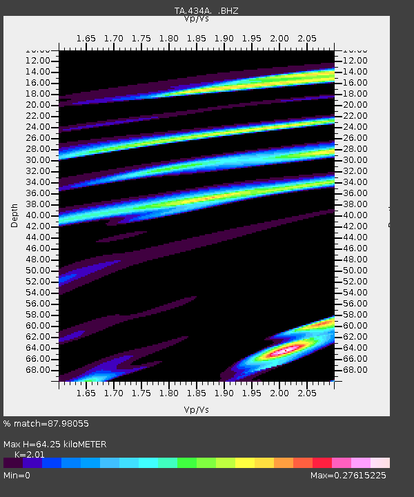
434A Burnet, TX, USA - Earthquake Result Viewer

Earthquake location: Rat Islands, Aleutian Islands
Earthquake latitude/longitude: 51.3/178.9
Earthquake time(UTC): 2011/07/18 (199) 22:38:38 GMT
Earthquake Depth: 19 km
Earthquake Magnitude: 5.8 MW, 5.3 MS, 5.4 MB, 5.8 MW
Earthquake Catalog/Contributor: WHDF/NEIC
Network: TA USArray Transportable Network (new EarthScope stations)
Station: 434A Burnet, TX, USA
Lat/Lon: 30.81 N/98.27 W
Elevation: 462 m
Distance: 62.3 deg
Az: 74.539 deg
Baz: 315.283 deg
Ray Param: 0.060282286
Estimated Moho Depth: 64.25 km
Estimated Crust Vp/Vs: 2.01
Assumed Crust Vp: 6.498 km/s
Estimated Crust Vs: 3.233 km/s
Estimated Crust Poisson's Ratio: 0.34
Radial Match: 87.98055 %
Radial Bump: 400
Transverse Match: 77.50947 %
Transverse Bump: 400
SOD ConfigId: 401841
Insert Time: 2011-12-21 04:51:10.061 +0000
GWidth: 2.5
Max Bumps: 400
Tol: 0.001

Signal To Noise

ChannelStoNSTALTA
TA:434A: :BHZ:20110718T22:48:28.899983Z15.078575.4376324E-73.6061987E-8
TA:434A: :BHN:20110718T22:48:28.899983Z3.69032261.4332336E-73.8837623E-8
TA:434A: :BHE:20110718T22:48:28.899983Z5.38403371.9951972E-73.7057667E-8
Arrivals
Ps10 SECOND
PpPs29 SECOND
PsPs/PpSs39 SECOND