336A Riesel, TX, USA - Earthquake Result Viewer
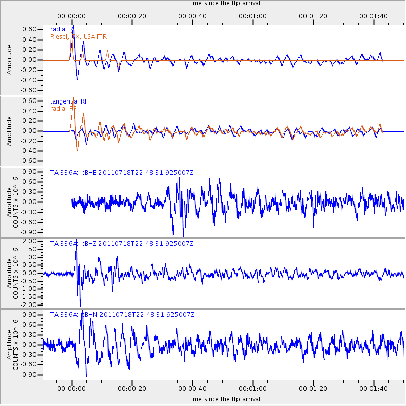
Earthquake location: Rat Islands, Aleutian Islands
Earthquake latitude/longitude: 51.3/178.9
Earthquake time(UTC): 2011/07/18 (199) 22:38:38 GMT
Earthquake Depth: 19 km
Earthquake Magnitude: 5.8 MW, 5.3 MS, 5.4 MB, 5.8 MW
Earthquake Catalog/Contributor: WHDF/NEIC
Network: TA USArray Transportable Network (new EarthScope stations)
Station: 336A Riesel, TX, USA
Lat/Lon: 31.39 N/96.84 W
Elevation: 140 m
Distance: 62.8 deg
Az: 73.107 deg
Baz: 315.355 deg
Ray Param: 0.059985913
Estimated Moho Depth: 21.0 km
Estimated Crust Vp/Vs: 1.90
Assumed Crust Vp: 6.347 km/s
Estimated Crust Vs: 3.341 km/s
Estimated Crust Poisson's Ratio: 0.31
Radial Match: 86.27756 %
Radial Bump: 400
Transverse Match: 77.659325 %
Transverse Bump: 400
SOD ConfigId: 401841
Insert Time: 2011-12-21 04:55:22.922 +0000
GWidth: 2.5
Max Bumps: 400
Tol: 0.001

Signal To Noise

ChannelStoNSTALTA
TA:336A: :BHZ:20110718T22:48:31.925007Z11.7372458.049373E-76.8579745E-8
TA:336A: :BHN:20110718T22:48:31.925007Z4.28114.6197664E-71.07910736E-7
TA:336A: :BHE:20110718T22:48:31.925007Z2.9735733.407962E-71.1460832E-7
Arrivals
Ps3.1 SECOND
PpPs9.2 SECOND
PsPs/PpSs12 SECOND