You are here: Home > Network List > TA - USArray Transportable Network (new EarthScope stations) Stations List
> Station U57A Blanch, NC, USA > Earthquake Result Viewer
U57A Blanch, NC, USA - Earthquake Result Viewer

| Earthquake location: |
Southern California |
| Earthquake latitude/longitude: |
33.9/-117.9 |
| Earthquake time(UTC): |
2014/03/29 (088) 04:09:43 GMT |
| Earthquake Depth: |
14 km |
| Earthquake Magnitude: |
5.1 MW |
| Earthquake Catalog/Contributor: |
ISC/ISC |
|
| Network: |
TA USArray Transportable Network (new EarthScope stations) |
| Station: |
U57A Blanch, NC, USA |
| Lat/Lon: |
36.43 N/79.34 W |
| Elevation: |
178 m |
|
| Distance: |
31.5 deg |
| Az: |
74.229 deg |
| Baz: |
276.928 deg |
| Ray Param: |
0.07903903 |
| Estimated Moho Depth: |
56.0 km |
| Estimated Crust Vp/Vs: |
1.79 |
| Assumed Crust Vp: |
6.419 km/s |
| Estimated Crust Vs: |
3.581 km/s |
| Estimated Crust Poisson's Ratio: |
0.27 |
|
| Radial Match: |
83.37509 % |
| Radial Bump: |
400 |
| Transverse Match: |
78.01113 % |
| Transverse Bump: |
400 |
| SOD ConfigId: |
3390531 |
| Insert Time: |
2019-04-10 22:49:01.067 +0000 |
| GWidth: |
2.5 |
| Max Bumps: |
400 |
| Tol: |
0.001 |
|
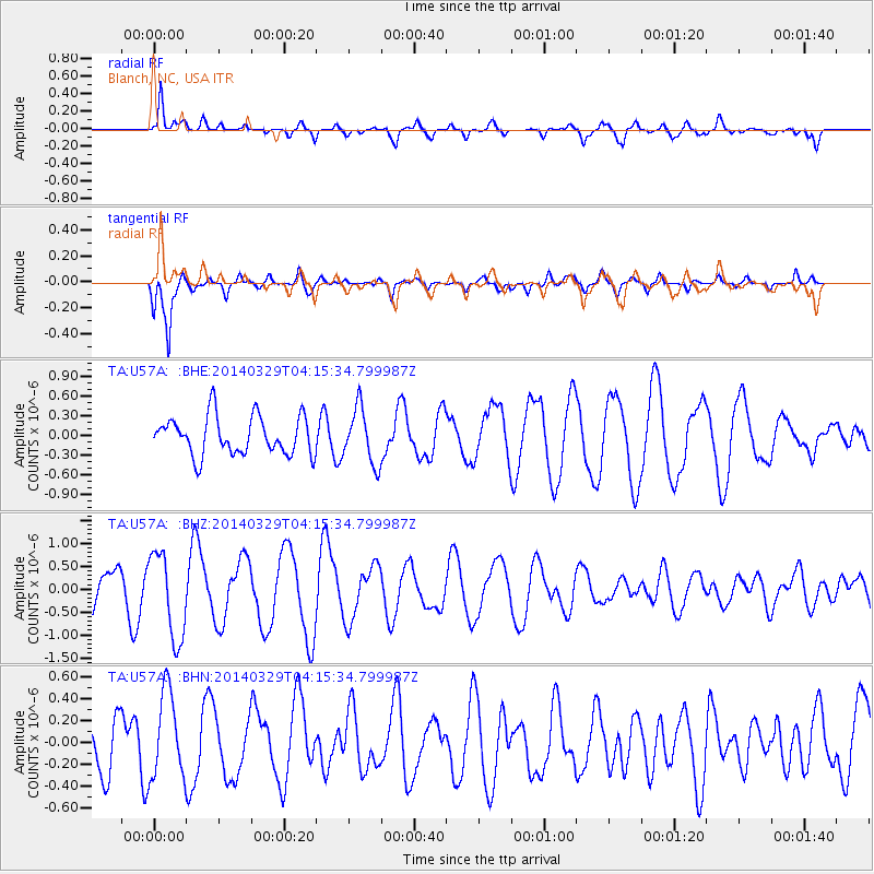
Signal To Noise
| Channel | StoN | STA | LTA |
| TA:U57A: :BHZ:20140329T04:15:34.799987Z | 1.9895334 | 9.377268E-7 | 4.7133E-7 |
| TA:U57A: :BHN:20140329T04:15:34.799987Z | 1.3644183 | 3.952407E-7 | 2.8967708E-7 |
| TA:U57A: :BHE:20140329T04:15:34.799987Z | 1.4294581 | 4.1956346E-7 | 2.9351224E-7 |
| Arrivals |
| Ps | 7.5 SECOND |
| PpPs | 23 SECOND |
| PsPs/PpSs | 30 SECOND |


