You are here: Home > Network List > TA - USArray Transportable Network (new EarthScope stations) Stations List
> Station C38A Sawbill Landing (USFS), Superior Nat. Forest, MN, > Earthquake Result Viewer
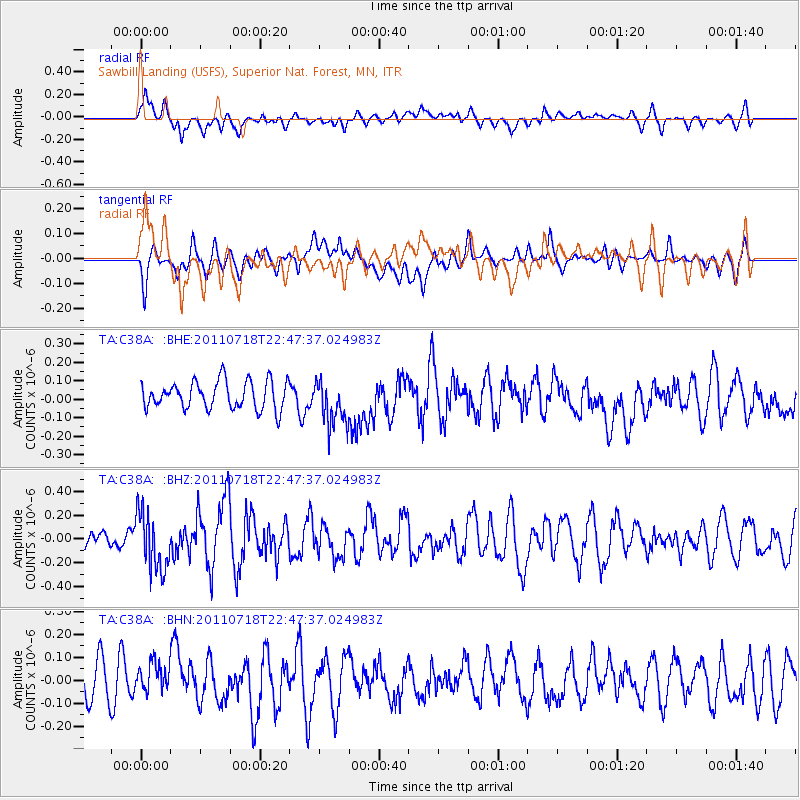
C38A Sawbill Landing (USFS), Superior Nat. Forest, MN, - Earthquake Result Viewer
*The percent match for this event was below the threshold and hence no stack was calculated.
| Earthquake location: |
Rat Islands, Aleutian Islands |
| Earthquake latitude/longitude: |
51.3/178.9 |
| Earthquake time(UTC): |
2011/07/18 (199) 22:38:38 GMT |
| Earthquake Depth: |
19 km |
| Earthquake Magnitude: |
5.8 MW, 5.3 MS, 5.4 MB, 5.8 MW |
| Earthquake Catalog/Contributor: |
WHDF/NEIC |
|
| Network: |
TA USArray Transportable Network (new EarthScope stations) |
| Station: |
C38A Sawbill Landing (USFS), Superior Nat. Forest, MN, |
| Lat/Lon: |
47.72 N/91.27 W |
| Elevation: |
498 m |
|
| Distance: |
54.9 deg |
| Az: |
55.664 deg |
| Baz: |
309.822 deg |
| Ray Param: |
$rayparam |
*The percent match for this event was below the threshold and hence was not used in the summary stack. |
|
| Radial Match: |
53.21932 % |
| Radial Bump: |
400 |
| Transverse Match: |
53.594944 % |
| Transverse Bump: |
400 |
| SOD ConfigId: |
401841 |
| Insert Time: |
2011-12-21 05:09:18.282 +0000 |
| GWidth: |
2.5 |
| Max Bumps: |
400 |
| Tol: |
0.001 |
|
Signal To Noise
| Channel | StoN | STA | LTA |
| TA:C38A: :BHZ:20110718T22:47:37.024983Z | 3.4552877 | 2.4297245E-7 | 7.0319025E-8 |
| TA:C38A: :BHN:20110718T22:47:37.024983Z | 0.86204714 | 6.5651754E-8 | 7.615797E-8 |
| TA:C38A: :BHE:20110718T22:47:37.024983Z | 1.6497191 | 1.2344579E-7 | 7.482837E-8 |
| Arrivals |
| Ps | |
| PpPs | |
| PsPs/PpSs | |


