You are here: Home > Network List > TA - USArray Transportable Network (new EarthScope stations) Stations List
> Station W37B Quinton, OK, USA > Earthquake Result Viewer
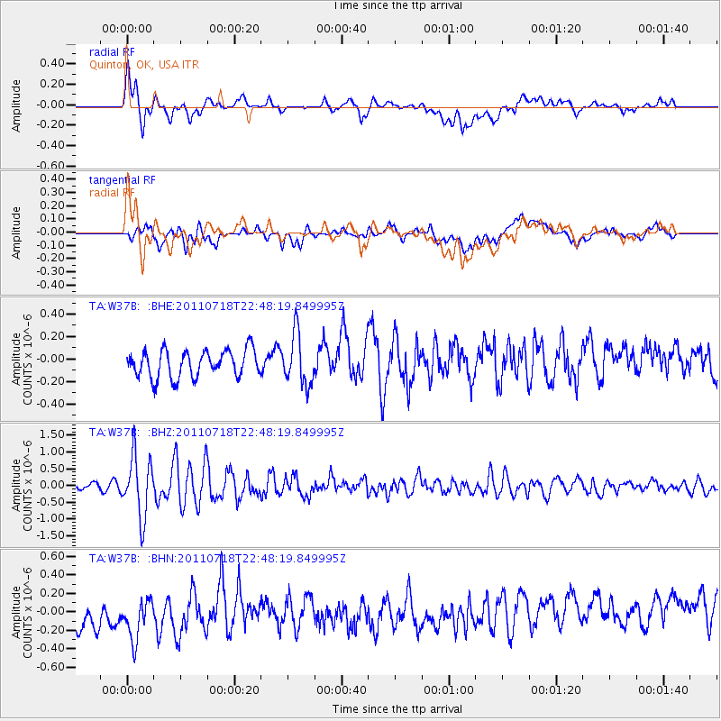
W37B Quinton, OK, USA - Earthquake Result Viewer
*The percent match for this event was below the threshold and hence no stack was calculated.
| Earthquake location: |
Rat Islands, Aleutian Islands |
| Earthquake latitude/longitude: |
51.3/178.9 |
| Earthquake time(UTC): |
2011/07/18 (199) 22:38:38 GMT |
| Earthquake Depth: |
19 km |
| Earthquake Magnitude: |
5.8 MW, 5.3 MS, 5.4 MB, 5.8 MW |
| Earthquake Catalog/Contributor: |
WHDF/NEIC |
|
| Network: |
TA USArray Transportable Network (new EarthScope stations) |
| Station: |
W37B Quinton, OK, USA |
| Lat/Lon: |
35.14 N/95.43 W |
| Elevation: |
279 m |
|
| Distance: |
61.0 deg |
| Az: |
69.151 deg |
| Baz: |
314.261 deg |
| Ray Param: |
$rayparam |
*The percent match for this event was below the threshold and hence was not used in the summary stack. |
|
| Radial Match: |
48.136208 % |
| Radial Bump: |
400 |
| Transverse Match: |
31.815025 % |
| Transverse Bump: |
400 |
| SOD ConfigId: |
401841 |
| Insert Time: |
2011-12-21 05:15:22.015 +0000 |
| GWidth: |
2.5 |
| Max Bumps: |
400 |
| Tol: |
0.001 |
|
Signal To Noise
| Channel | StoN | STA | LTA |
| TA:W37B: :BHZ:20110718T22:48:19.849995Z | 7.7909627 | 9.07313E-7 | 1.16457116E-7 |
| TA:W37B: :BHN:20110718T22:48:19.849995Z | 0.9886337 | 3.418271E-7 | 3.457571E-7 |
| TA:W37B: :BHE:20110718T22:48:19.849995Z | 1.9288844 | 2.3207271E-7 | 1.2031448E-7 |
| Arrivals |
| Ps | |
| PpPs | |
| PsPs/PpSs | |


