You are here: Home > Network List > TA - USArray Transportable Network (new EarthScope stations) Stations List
> Station J01E Myrtle Point, OR, USA > Earthquake Result Viewer
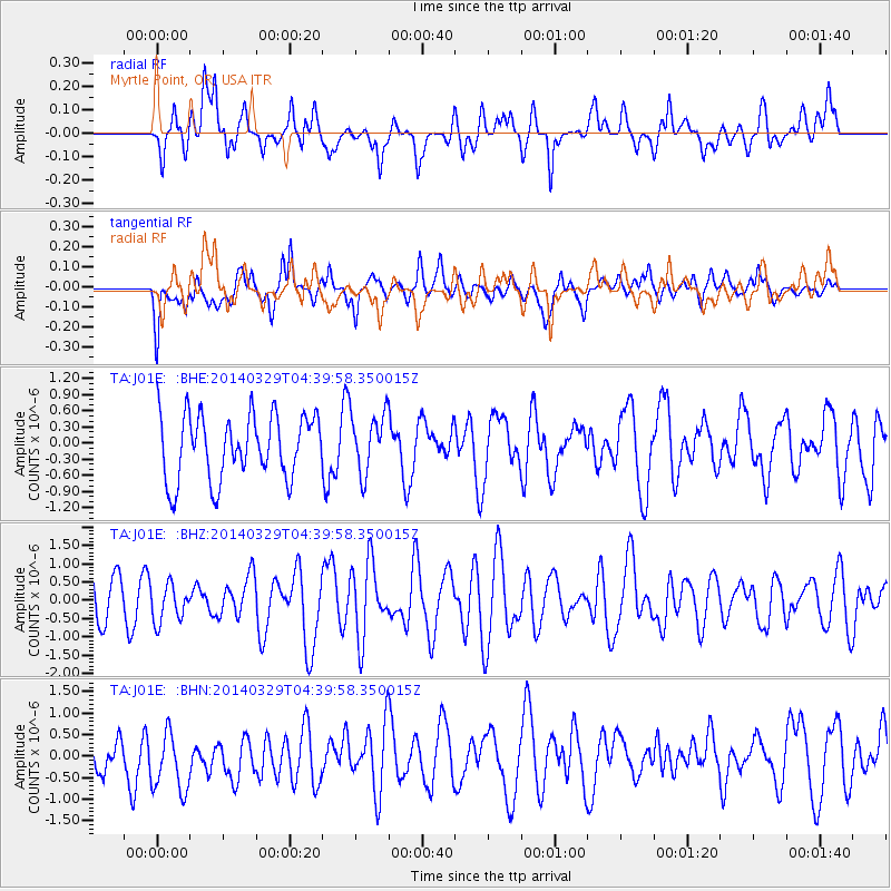
J01E Myrtle Point, OR, USA - Earthquake Result Viewer
*The percent match for this event was below the threshold and hence no stack was calculated.
| Earthquake location: |
South Of Kermadec Islands |
| Earthquake latitude/longitude: |
-34.6/179.7 |
| Earthquake time(UTC): |
2014/03/29 (088) 04:27:50 GMT |
| Earthquake Depth: |
300 km |
| Earthquake Magnitude: |
4.0 mb |
| Earthquake Catalog/Contributor: |
ISC/ISC |
|
| Network: |
TA USArray Transportable Network (new EarthScope stations) |
| Station: |
J01E Myrtle Point, OR, USA |
| Lat/Lon: |
43.16 N/123.93 W |
| Elevation: |
128 m |
|
| Distance: |
92.9 deg |
| Az: |
37.569 deg |
| Baz: |
223.45 deg |
| Ray Param: |
$rayparam |
*The percent match for this event was below the threshold and hence was not used in the summary stack. |
|
| Radial Match: |
61.001556 % |
| Radial Bump: |
400 |
| Transverse Match: |
57.0544 % |
| Transverse Bump: |
400 |
| SOD ConfigId: |
3390531 |
| Insert Time: |
2019-04-10 22:52:17.895 +0000 |
| GWidth: |
2.5 |
| Max Bumps: |
400 |
| Tol: |
0.001 |
|
Signal To Noise
| Channel | StoN | STA | LTA |
| TA:J01E: :BHZ:20140329T04:39:58.350015Z | 0.70634735 | 5.1379845E-7 | 7.27402E-7 |
| TA:J01E: :BHN:20140329T04:39:58.350015Z | 1.579293 | 8.1487156E-7 | 5.159724E-7 |
| TA:J01E: :BHE:20140329T04:39:58.350015Z | 0.93492717 | 5.5934055E-7 | 5.9827175E-7 |
| Arrivals |
| Ps | |
| PpPs | |
| PsPs/PpSs | |


