You are here: Home > Network List > TA - USArray Transportable Network (new EarthScope stations) Stations List
> Station O41A Passley's Farm, La Prairie, IL, USA > Earthquake Result Viewer
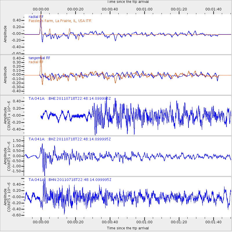
O41A Passley's Farm, La Prairie, IL, USA - Earthquake Result Viewer
*The percent match for this event was below the threshold and hence no stack was calculated.
| Earthquake location: |
Rat Islands, Aleutian Islands |
| Earthquake latitude/longitude: |
51.3/178.9 |
| Earthquake time(UTC): |
2011/07/18 (199) 22:38:38 GMT |
| Earthquake Depth: |
19 km |
| Earthquake Magnitude: |
5.8 MW, 5.3 MS, 5.4 MB, 5.8 MW |
| Earthquake Catalog/Contributor: |
WHDF/NEIC |
|
| Network: |
TA USArray Transportable Network (new EarthScope stations) |
| Station: |
O41A Passley's Farm, La Prairie, IL, USA |
| Lat/Lon: |
40.12 N/90.88 W |
| Elevation: |
203 m |
|
| Distance: |
60.1 deg |
| Az: |
62.166 deg |
| Baz: |
313.594 deg |
| Ray Param: |
$rayparam |
*The percent match for this event was below the threshold and hence was not used in the summary stack. |
|
| Radial Match: |
69.287544 % |
| Radial Bump: |
400 |
| Transverse Match: |
50.82574 % |
| Transverse Bump: |
400 |
| SOD ConfigId: |
401841 |
| Insert Time: |
2011-12-21 05:23:55.227 +0000 |
| GWidth: |
2.5 |
| Max Bumps: |
400 |
| Tol: |
0.001 |
|
Signal To Noise
| Channel | StoN | STA | LTA |
| TA:O41A: :BHZ:20110718T22:48:14.099995Z | 9.740473 | 7.034044E-7 | 7.2214604E-8 |
| TA:O41A: :BHN:20110718T22:48:14.099995Z | 2.4376917 | 2.2628085E-7 | 9.2825864E-8 |
| TA:O41A: :BHE:20110718T22:48:14.099995Z | 3.1288362 | 2.181689E-7 | 6.972845E-8 |
| Arrivals |
| Ps | |
| PpPs | |
| PsPs/PpSs | |


