You are here: Home > Network List > UW - Pacific Northwest Regional Seismic Network Stations List
> Station HOOD Mt Hood Meadows, OR CREST BB SMO > Earthquake Result Viewer
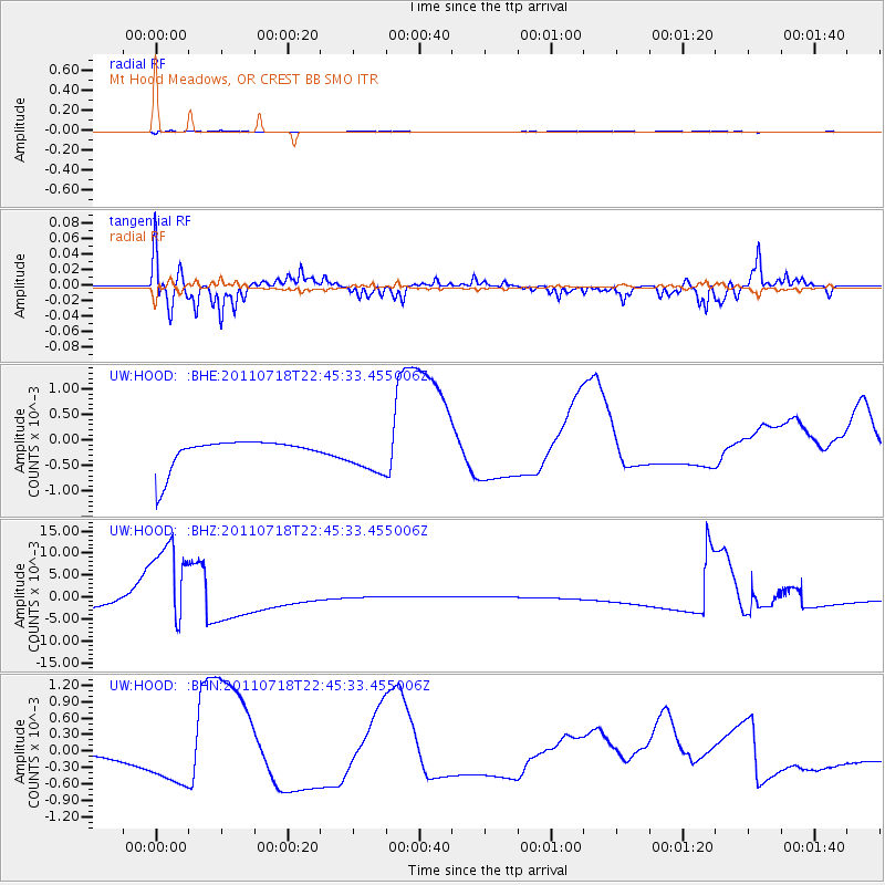
HOOD Mt Hood Meadows, OR CREST BB SMO - Earthquake Result Viewer
*The percent match for this event was below the threshold and hence no stack was calculated.
| Earthquake location: |
Rat Islands, Aleutian Islands |
| Earthquake latitude/longitude: |
51.3/178.9 |
| Earthquake time(UTC): |
2011/07/18 (199) 22:38:38 GMT |
| Earthquake Depth: |
19 km |
| Earthquake Magnitude: |
5.8 MW, 5.3 MS, 5.4 MB, 5.8 MW |
| Earthquake Catalog/Contributor: |
WHDF/NEIC |
|
| Network: |
UW Pacific Northwest Regional Seismic Network |
| Station: |
HOOD Mt Hood Meadows, OR CREST BB SMO |
| Lat/Lon: |
45.32 N/121.65 W |
| Elevation: |
1520 m |
|
| Distance: |
39.0 deg |
| Az: |
74.741 deg |
| Baz: |
300.813 deg |
| Ray Param: |
$rayparam |
*The percent match for this event was below the threshold and hence was not used in the summary stack. |
|
| Radial Match: |
62.90199 % |
| Radial Bump: |
369 |
| Transverse Match: |
62.657444 % |
| Transverse Bump: |
336 |
| SOD ConfigId: |
401841 |
| Insert Time: |
2011-12-21 05:27:42.629 +0000 |
| GWidth: |
2.5 |
| Max Bumps: |
400 |
| Tol: |
0.001 |
|
Signal To Noise
| Channel | StoN | STA | LTA |
| UW:HOOD: :BHZ:20110718T22:45:33.455006Z | 13.411427 | 0.011095377 | 8.273077E-4 |
| UW:HOOD: :BHN:20110718T22:45:33.455006Z | 1.0678548 | 3.2057043E-4 | 3.002004E-4 |
| UW:HOOD: :BHE:20110718T22:45:33.455006Z | 1.2995996 | 3.6134874E-4 | 2.780462E-4 |
| Arrivals |
| Ps | |
| PpPs | |
| PsPs/PpSs | |


