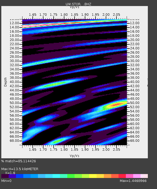
STOR Enumclaw, WA, USA - Earthquake Result Viewer

Earthquake location: Rat Islands, Aleutian Islands
Earthquake latitude/longitude: 51.3/178.9
Earthquake time(UTC): 2011/07/18 (199) 22:38:38 GMT
Earthquake Depth: 19 km
Earthquake Magnitude: 5.8 MW, 5.3 MS, 5.4 MB, 5.8 MW
Earthquake Catalog/Contributor: WHDF/NEIC
Network: UW Pacific Northwest Regional Seismic Network
Station: STOR Enumclaw, WA, USA
Lat/Lon: 47.19 N/121.99 W
Elevation: 266 m
Distance: 37.9 deg
Az: 72.319 deg
Baz: 298.674 deg
Ray Param: 0.075860105
Estimated Moho Depth: 13.5 km
Estimated Crust Vp/Vs: 1.60
Assumed Crust Vp: 6.597 km/s
Estimated Crust Vs: 4.123 km/s
Estimated Crust Poisson's Ratio: 0.18
Radial Match: 85.114426 %
Radial Bump: 400
Transverse Match: 66.25299 %
Transverse Bump: 400
SOD ConfigId: 401841
Insert Time: 2011-12-21 05:28:14.353 +0000
GWidth: 2.5
Max Bumps: 400
Tol: 0.001

Signal To Noise

ChannelStoNSTALTA
UW:STOR: :BHZ:20110718T22:45:23.950001Z6.85738567.9679705E-71.1619546E-7
UW:STOR: :BHN:20110718T22:45:23.950001Z2.6262432.6686655E-71.0161532E-7
UW:STOR: :BHE:20110718T22:45:23.950001Z2.13078333.121665E-71.4650315E-7
Arrivals
Ps1.3 SECOND
PpPs4.9 SECOND
PsPs/PpSs6.2 SECOND