You are here: Home > Network List > IC - New China Digital Seismograph Network Stations List
> Station ENH Enshi, Hubei Province, China > Earthquake Result Viewer
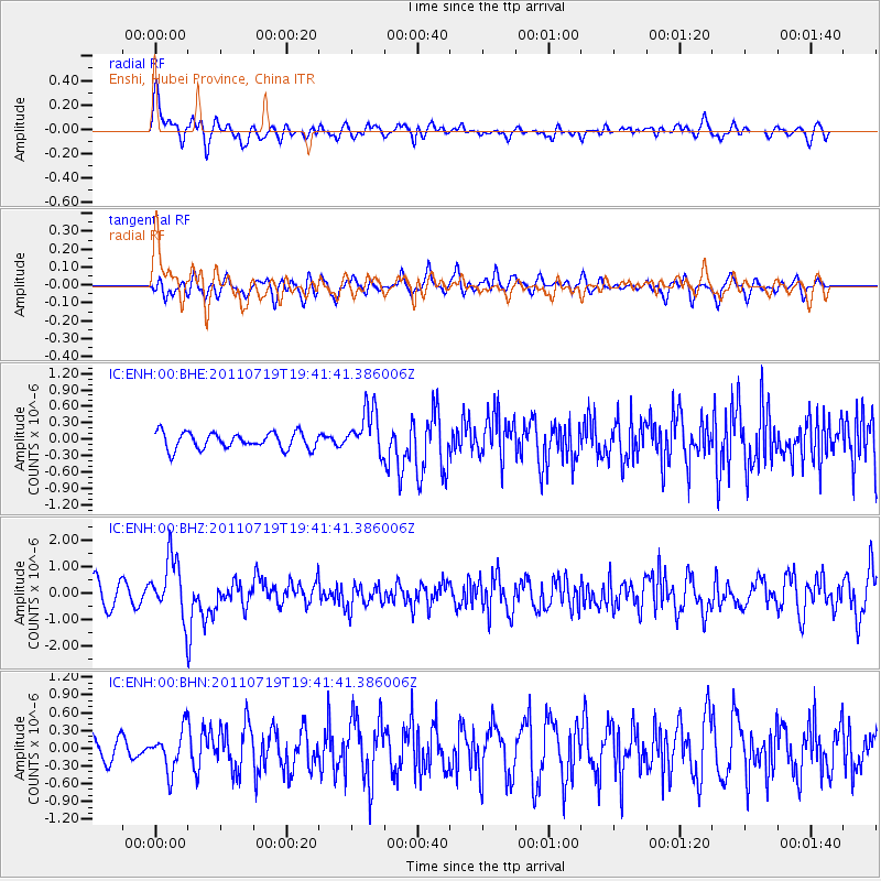
ENH Enshi, Hubei Province, China - Earthquake Result Viewer
*The percent match for this event was below the threshold and hence no stack was calculated.
| Earthquake location: |
Tajikistan |
| Earthquake latitude/longitude: |
40.1/71.4 |
| Earthquake time(UTC): |
2011/07/19 (200) 19:35:43 GMT |
| Earthquake Depth: |
20 km |
| Earthquake Magnitude: |
6.1 MB, 6.2 MS, 6.1 MW, 6.0 MW |
| Earthquake Catalog/Contributor: |
WHDF/NEIC |
|
| Network: |
IC New China Digital Seismograph Network |
| Station: |
ENH Enshi, Hubei Province, China |
| Lat/Lon: |
30.28 N/109.49 E |
| Elevation: |
500 m |
|
| Distance: |
32.4 deg |
| Az: |
95.544 deg |
| Baz: |
298.02 deg |
| Ray Param: |
$rayparam |
*The percent match for this event was below the threshold and hence was not used in the summary stack. |
|
| Radial Match: |
68.14389 % |
| Radial Bump: |
400 |
| Transverse Match: |
68.53834 % |
| Transverse Bump: |
400 |
| SOD ConfigId: |
401841 |
| Insert Time: |
2011-12-21 05:46:54.379 +0000 |
| GWidth: |
2.5 |
| Max Bumps: |
400 |
| Tol: |
0.001 |
|
Signal To Noise
| Channel | StoN | STA | LTA |
| IC:ENH:00:BHZ:20110719T19:41:41.386006Z | 2.861006 | 1.1051825E-6 | 3.8629156E-7 |
| IC:ENH:00:BHN:20110719T19:41:41.386006Z | 1.5238278 | 3.4250422E-7 | 2.2476571E-7 |
| IC:ENH:00:BHE:20110719T19:41:41.386006Z | 2.7687144 | 4.1228313E-7 | 1.4890777E-7 |
| Arrivals |
| Ps | |
| PpPs | |
| PsPs/PpSs | |


