You are here: Home > Network List > IW - Intermountain West Stations List
> Station MOOW Moose Ponds, Wyoming, USA > Earthquake Result Viewer
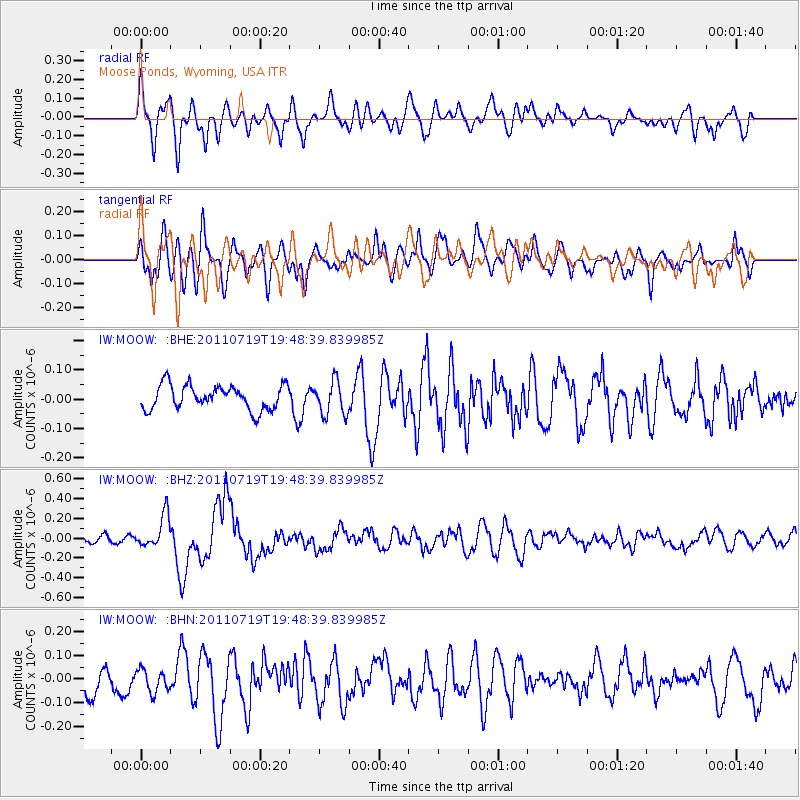
MOOW Moose Ponds, Wyoming, USA - Earthquake Result Viewer
*The percent match for this event was below the threshold and hence no stack was calculated.
| Earthquake location: |
Tajikistan |
| Earthquake latitude/longitude: |
40.1/71.4 |
| Earthquake time(UTC): |
2011/07/19 (200) 19:35:43 GMT |
| Earthquake Depth: |
20 km |
| Earthquake Magnitude: |
6.1 MB, 6.2 MS, 6.1 MW, 6.0 MW |
| Earthquake Catalog/Contributor: |
WHDF/NEIC |
|
| Network: |
IW Intermountain West |
| Station: |
MOOW Moose Ponds, Wyoming, USA |
| Lat/Lon: |
43.75 N/110.74 W |
| Elevation: |
2128 m |
|
| Distance: |
96.5 deg |
| Az: |
1.572 deg |
| Baz: |
358.336 deg |
| Ray Param: |
$rayparam |
*The percent match for this event was below the threshold and hence was not used in the summary stack. |
|
| Radial Match: |
69.47036 % |
| Radial Bump: |
400 |
| Transverse Match: |
66.37316 % |
| Transverse Bump: |
400 |
| SOD ConfigId: |
401841 |
| Insert Time: |
2011-12-21 05:48:37.821 +0000 |
| GWidth: |
2.5 |
| Max Bumps: |
400 |
| Tol: |
0.001 |
|
Signal To Noise
| Channel | StoN | STA | LTA |
| IW:MOOW: :BHZ:20110719T19:48:39.839985Z | 2.8917692 | 1.659334E-7 | 5.738128E-8 |
| IW:MOOW: :BHN:20110719T19:48:39.839985Z | 0.86421466 | 4.8135508E-8 | 5.5698553E-8 |
| IW:MOOW: :BHE:20110719T19:48:39.839985Z | 1.3948287 | 5.7753784E-8 | 4.140565E-8 |
| Arrivals |
| Ps | |
| PpPs | |
| PsPs/PpSs | |


