You are here: Home > Network List > MN - MEDNET Project Stations List
> Station WDD Wield Dalam, Malta > Earthquake Result Viewer
WDD Wield Dalam, Malta - Earthquake Result Viewer

| Earthquake location: |
Tajikistan |
| Earthquake latitude/longitude: |
40.1/71.4 |
| Earthquake time(UTC): |
2011/07/19 (200) 19:35:43 GMT |
| Earthquake Depth: |
20 km |
| Earthquake Magnitude: |
6.1 MB, 6.2 MS, 6.1 MW, 6.0 MW |
| Earthquake Catalog/Contributor: |
WHDF/NEIC |
|
| Network: |
MN MEDNET Project |
| Station: |
WDD Wield Dalam, Malta |
| Lat/Lon: |
35.87 N/14.52 E |
| Elevation: |
41 m |
|
| Distance: |
44.4 deg |
| Az: |
283.472 deg |
| Baz: |
66.726 deg |
| Ray Param: |
0.07191852 |
| Estimated Moho Depth: |
47.0 km |
| Estimated Crust Vp/Vs: |
1.74 |
| Assumed Crust Vp: |
4.05 km/s |
| Estimated Crust Vs: |
2.328 km/s |
| Estimated Crust Poisson's Ratio: |
0.25 |
|
| Radial Match: |
83.46832 % |
| Radial Bump: |
400 |
| Transverse Match: |
76.14814 % |
| Transverse Bump: |
400 |
| SOD ConfigId: |
401841 |
| Insert Time: |
2011-12-21 05:50:18.897 +0000 |
| GWidth: |
2.5 |
| Max Bumps: |
400 |
| Tol: |
0.001 |
|
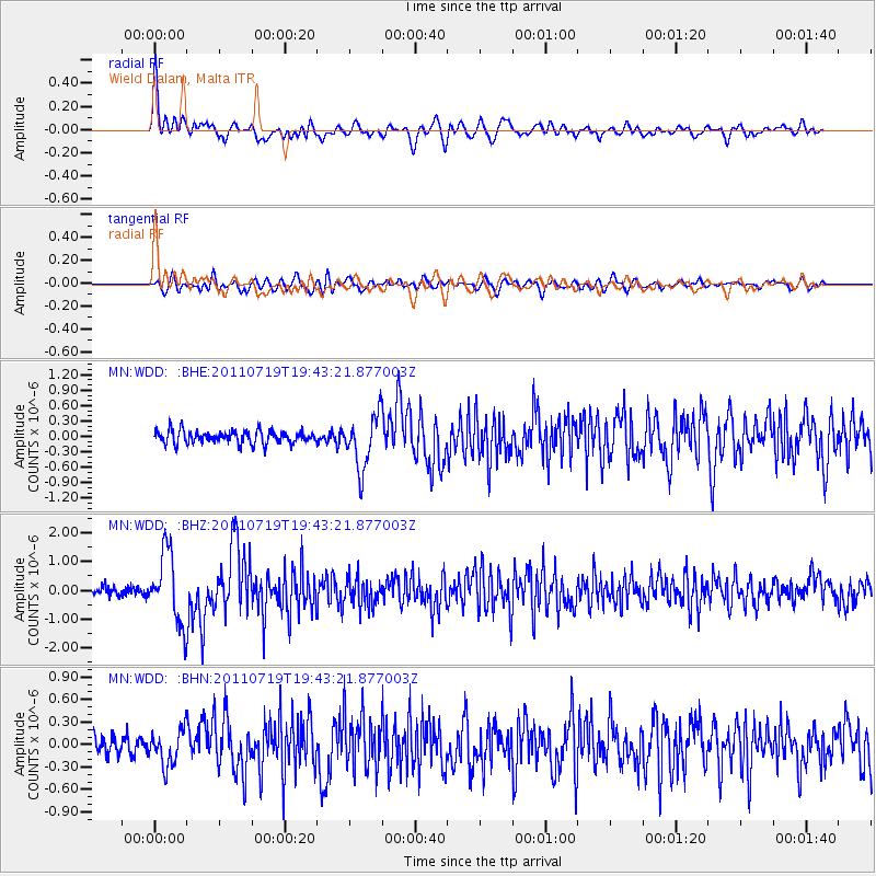
Signal To Noise
| Channel | StoN | STA | LTA |
| MN:WDD: :BHZ:20110719T19:43:21.877003Z | 9.264452 | 1.2038046E-6 | 1.2993803E-7 |
| MN:WDD: :BHN:20110719T19:43:21.877003Z | 1.8810871 | 2.3715701E-7 | 1.2607444E-7 |
| MN:WDD: :BHE:20110719T19:43:21.877003Z | 4.213986 | 5.145395E-7 | 1.2210282E-7 |
| Arrivals |
| Ps | 8.8 SECOND |
| PpPs | 31 SECOND |
| PsPs/PpSs | 40 SECOND |


